Kuchurhan geodata
Kuchurhan (Odesa) is a populated place; located in Ukraine in Europe/Kiev (GMT+3) time zone. With population of 3,183 people, there are 891 cities with bigger population in this country. Compared to other cities in Ukraine, 63% of cities are located further ↑North; 68.9% of cities are located further →East and 76.7% of cities have higher elevation than Kuchurhan. Note1


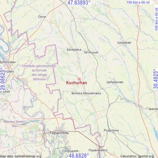
Kuchurhan GPS coordinates[2]
47° 9' 46.872" North, 29° 47' 21.732" East
| Map corner | latitude | longitude |
|---|---|---|
| Upper-left | 47.63893°, | 29.08625° |
| Center: | 47.16302°, | 29.78937° |
| Lower-right: | 46.6828°, | 30.4925° |
| Map W x H: | 106.3×106.3 km | = 66.1×66.1mi |
| max Lat: | 52.18903° ⇑63% North |
| Kuchurhan: | 47.16302° |
| min Lat: | ⇓37% South 44.39214° |
| min Long | Kuchurhan | max Long |
| 22.20555° | 29.78937° | 40.13222° |
| W 31.1%⇐ | ⇒68.9% E |
Elevation
Elevation of Kuchurhan is 54 m = 177 ft, and this is 101.8 m = 334 ft below average elevation for this country.
| Max E: |
886 m = 2907 ft | 76.7% |
| Avg. | 155.8 m = 511 ft | |
| Kuchurhan | 54 m = 177 ft | |
Min E: |
-3 m = -10 ft | 23.3% |
See also: Ukraine elevation on elevation.city.
Geographical zone
Kuchurhan is located in North temperate zone (between Tropic of Cancer and the Arctic Circle). Distance of this North polar circle is 2157.1 km =1340.4 mi to North.| Distance of | km | miles | from Kuchurhan |
|---|---|---|---|
| North Pole | 4763 | 2959.6 | to North |
| Arctic Circle | 2157.1 | 1340.4 | to North |
| Tropic Cancer | 2638.1 | 1639.2 | to South |
| Equator | 5244 | 3258.5 | to South |


Nearby cities:
15 places around Kuchurhan: (largest is in red/bold)
• Ananyiv Pershyi
63.1 km =39.2 mi,  10°
10°
• Ivanivka
55.6 km =34.5 mi,  112°
112°
• Lymanske
58 km =36 mi,  166°
166°
• Mayaky
35.4 km =22 mi,  330°
330°
• Okny
48.8 km =30.3 mi, 329°
• Pavlivka
47.2 km =29.3 mi,  161°
161°
• Podil’s’k
68.4 km =42.5 mi,  343°
343°
• Rozdil’na
41.8 km =26 mi,  148°
148°
• Shyryayeve
39.1 km =24.3 mi,  51°
51°
• Stepanivka
43.6 km =27.1 mi, 159°
• Stepove
55.6 km =34.5 mi, 156°
• Velyka Mykhaylivka
10.6 km =6.6 mi, 150°
• Velykoploske
19 km =11.8 mi,  208°
208°
• Zakharivka
19 km =11.8 mi,  353°
353°
• Zatyshshya
20 km =12.4 mi,  18°
18°
Sources, notices
• [Note1] Compared only with cities in Ukraine existing in our database
• [Src1] Map data: © OpenStreetMap contributors (CC-BY-SA)
• [Src2] Other city data from geonames.org with taken over terms of usage.
• [Src3] Geographical zone / Annual Mean Temperature by Robert A. Rohde @ Wikipedia
