Malyn geodata
Malyn (Zhytomyr) is a seat of a second-order administrative division; located in Ukraine in Europe/Kiev (GMT+3) time zone. With population of 27,068 people, there are 158 cities with bigger population in this country. Compared to other cities in Ukraine, 94% of cities are located further ↓South; 71.4% of cities are located further →East and 58.1% of cities have lower elevation than Malyn. Note1


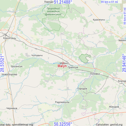
Malyn GPS coordinates[2]
50° 46' 20.388" North, 29° 14' 17.988" East
| Map corner | latitude | longitude |
|---|---|---|
| Upper-left | 51.21488°, | 28.53521° |
| Center: | 50.77233°, | 29.23833° |
| Lower-right: | 50.32556°, | 29.94146° |
| Map W x H: | 98.9×98.9 km | = 61.5×61.5mi |
| max Lat: | 52.18903° ⇑6% North |
| Malyn: | 50.77233° |
| min Lat: | ⇓94% South 44.39214° |
| min Long | Malyn | max Long |
| 22.20555° | 29.23833° | 40.13222° |
| W 28.6%⇐ | ⇒71.4% E |
Elevation
Elevation of Malyn is 161 m = 528 ft, and this is 5.2 m = 17 ft above average elevation for this country.
| Max E: |
886 m = 2907 ft | 41.9% |
| Malyn | 161 m 528 ft | |
| Avg. | 155.8 m = 511 ft | |
Min E: |
-3 m = -10 ft | 58.1% |
See also: Ukraine elevation on elevation.city.
Geographical zone
Malyn is located in North temperate zone (between Tropic of Cancer and the Arctic Circle). Distance of this North polar circle is 1755.8 km =1091 mi to North.| Distance of | km | miles | from Malyn |
|---|---|---|---|
| North Pole | 4361.7 | 2710.2 | to North |
| Arctic Circle | 1755.8 | 1091 | to North |
| Tropic Cancer | 3039.4 | 1888.6 | to South |
| Equator | 5645.4 | 3507.9 | to South |


Nearby cities:
15 places around Malyn: (largest is in red/bold)
• Bila Krynytsya
22 km =13.7 mi,  132°
132°
• Borodianka
50.1 km =31.1 mi,  106°
106°
• Chopovychi
21.1 km =13.1 mi,  288°
288°
• Holovyne
44.4 km =27.6 mi,  221°
221°
• Horodok
25.2 km =15.7 mi,  141°
141°
• Ivankiv
49.6 km =30.8 mi,  68°
68°
• Kodra
30 km =18.6 mi, 131°
• Korosten’
46.9 km =29.1 mi,  296°
296°
• Korostyshiv
52.2 km =32.4 mi,  194°
194°
• Krasyatychi
44.4 km =27.6 mi,  40°
40°
• Narodychi
49.1 km =30.5 mi,  347°
347°
• Nova Borova
43.4 km =27 mi,  258°
258°
• Piskivka
28.2 km =17.5 mi, 108°
• Radomyshl
30.7 km =19.1 mi,  181°
181°
• Stavyshche
46.1 km =28.6 mi,  153°
153°
Sources, notices
• [Note1] Compared only with cities in Ukraine existing in our database
• [Src1] Map data: © OpenStreetMap contributors (CC-BY-SA)
• [Src2] Other city data from geonames.org with taken over terms of usage.
• [Src3] Geographical zone / Annual Mean Temperature by Robert A. Rohde @ Wikipedia
