Chopovychi geodata
Chopovychi (Zhytomyr) is a populated place; located in Ukraine in Europe/Kiev (GMT+3) time zone. With population of 2,183 people, there are 1079 cities with bigger population in this country. Compared to other cities in Ukraine, 94.7% of cities are located further ↓South; 72.7% of cities are located further →East and 59.7% of cities have lower elevation than Chopovychi. Note1
Administrative division(s):
- Level 1: Zhytomyr
- Level 2: Malyn Raion
- Level 3: Chopovychi United Territorial Community


Chopovychi GPS coordinates[2]
50° 49' 59.7" North, 28° 57' 12.024" East
| Map corner | latitude | longitude |
|---|---|---|
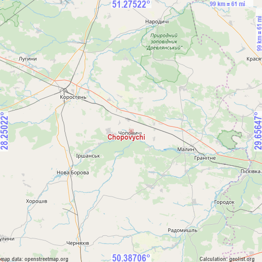
| Upper-left | 51.27522°, | 28.25022° |
| Center: | 50.83325°, | 28.95334° |
| Lower-right: | 50.38706°, | 29.65647° |
| Map W x H: | 98.8×98.8 km | = 61.4×61.4mi |
| max Lat: | 52.18903° ⇑5.3% North |
| Chopovychi: | 50.83325° |
| min Lat: | ⇓94.7% South 44.39214° |
| min Long | Chopovychi | max Long |
| 22.20555° | 28.95334° | 40.13222° |
| W 27.3%⇐ | ⇒72.7% E |
Elevation
Elevation of Chopovychi is 168 m = 551 ft, and this is 12.2 m = 40 ft above average elevation for this country.
| Max E: |
886 m = 2907 ft | 40.3% |
| Chopovychi | 168 m 551 ft | |
| Avg. | 155.8 m = 511 ft | |
Min E: |
-3 m = -10 ft | 59.7% |
See also: Ukraine elevation on elevation.city.
Geographical zone
Chopovychi is located in North temperate zone (between Tropic of Cancer and the Arctic Circle). Distance of this North polar circle is 1749 km =1086.8 mi to North.| Distance of | km | miles | from Chopovychi |
|---|---|---|---|
| North Pole | 4354.9 | 2706 | to North |
| Arctic Circle | 1749 | 1086.8 | to North |
| Tropic Cancer | 3046.2 | 1892.8 | to South |
| Equator | 5652.1 | 3512.1 | to South |


Nearby cities:
15 places around Chopovychi: (largest is in red/bold)
• Bila Krynytsya
42.3 km =26.3 mi,  120°
120°
• Cherniakhiv
46.4 km =28.8 mi,  205°
205°
• Holovyne
41.3 km =25.7 mi,  192°
192°
• Horodok
44.5 km =27.7 mi,  126°
126°
• Khoroshiv
44.5 km =27.7 mi,  233°
233°
• Kodra
50.2 km =31.2 mi, 121°
• Korosten’
26.2 km =16.3 mi,  302°
302°
• Krasyatychi
55.7 km =34.6 mi,  60°
60°
• Luhyny
47.6 km =29.6 mi,  305°
305°
• Malyn
21.1 km =13.1 mi,  108°
108°
• Narodychi
42.1 km =26.2 mi,  12°
12°
• Nova Borova
27.3 km =17 mi,  235°
235°
• Ovruch
55.6 km =34.5 mi,  349°
349°
• Piskivka
49.3 km =30.6 mi, 108°
• Radomyshl
42.2 km =26.2 mi,  152°
152°
Sources, notices
• [Note1] Compared only with cities in Ukraine existing in our database
• [Src1] Map data: © OpenStreetMap contributors (CC-BY-SA)
• [Src2] Other city data from geonames.org with taken over terms of usage.
• [Src3] Geographical zone / Annual Mean Temperature by Robert A. Rohde @ Wikipedia
