Bohuslav geodata
Bohuslav (Kyiv) is a seat of a second-order administrative division; located in Ukraine in Europe/Kiev (GMT+3) time zone. With population of 16,498 people, there are 234 cities with bigger population in this country. Compared to other cities in Ukraine, 75.5% of cities are located further ↓South; 62.2% of cities are located further →East and 58.8% of cities have lower elevation than Bohuslav. Note1


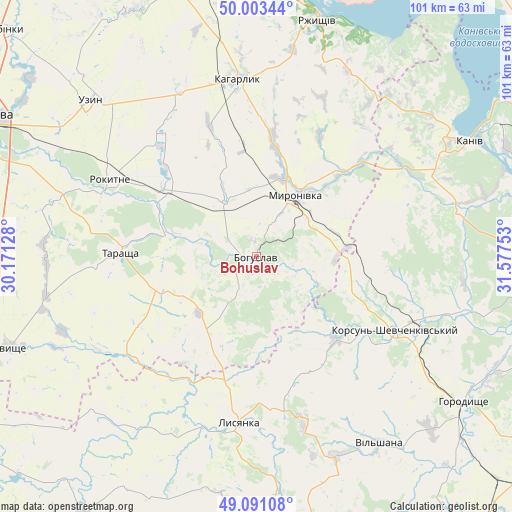
Bohuslav GPS coordinates[2]
49° 32' 57.804" North, 30° 52' 27.84" East
| Map corner | latitude | longitude |
|---|---|---|
| Upper-left | 50.00344°, | 30.17128° |
| Center: | 49.54939°, | 30.8744° |
| Lower-right: | 49.09108°, | 31.57753° |
| Map W x H: | 101.4×101.4 km | = 63×63mi |
| max Lat: | 52.18903° ⇑24.5% North |
| Bohuslav: | 49.54939° |
| min Lat: | ⇓75.5% South 44.39214° |
| min Long | Bohuslav | max Long |
| 22.20555° | 30.8744° | 40.13222° |
| W 37.8%⇐ | ⇒62.2% E |
Elevation
Elevation of Bohuslav is 164 m = 538 ft, and this is 8.2 m = 27 ft above average elevation for this country.
| Max E: |
886 m = 2907 ft | 41.2% |
| Bohuslav | 164 m 538 ft | |
| Avg. | 155.8 m = 511 ft | |
Min E: |
-3 m = -10 ft | 58.8% |
See also: Ukraine elevation on elevation.city.
Geographical zone
Bohuslav is located in North temperate zone (between Tropic of Cancer and the Arctic Circle). Distance of this North polar circle is 1891.8 km =1175.5 mi to North.| Distance of | km | miles | from Bohuslav |
|---|---|---|---|
| North Pole | 4497.7 | 2794.7 | to North |
| Arctic Circle | 1891.8 | 1175.5 | to North |
| Tropic Cancer | 2903.5 | 1804.2 | to South |
| Equator | 5509.4 | 3423.4 | to South |


Nearby cities:
15 places around Bohuslav: (largest is in red/bold)
• Horodyshche
50.7 km =31.5 mi,  125°
125°
• Kaharlyk
35 km =21.7 mi,  354°
354°
• Kalynove
35.8 km =22.2 mi,  238°
238°
• Kaniv
47.8 km =29.7 mi,  61°
61°
• Karapyshi
12 km =7.5 mi,  329°
329°
• Korsun-Shevchenkivskyi
31.3 km =19.4 mi,  117°
117°
• Lysianka
33.2 km =20.6 mi,  185°
185°
• Mirovka
46.1 km =28.6 mi,  336°
336°
• Mliiv
52.1 km =32.4 mi, 116°
• Myronivka
14.6 km =9.1 mi,  32°
32°
• Rokytne
32.6 km =20.3 mi,  297°
297°
• Rzhyshchiv
48.2 km =30 mi,  14°
14°
• Stebliv
23 km =14.3 mi,  135°
135°
• Tarashcha
27.6 km =17.1 mi,  272°
272°
• Uzyn
45.2 km =28.1 mi,  312°
312°
Sources, notices
• [Note1] Compared only with cities in Ukraine existing in our database
• [Src1] Map data: © OpenStreetMap contributors (CC-BY-SA)
• [Src2] Other city data from geonames.org with taken over terms of usage.
• [Src3] Geographical zone / Annual Mean Temperature by Robert A. Rohde @ Wikipedia
