Karapyshi geodata
Karapyshi (Kyiv) is a populated place; located in Ukraine in Europe/Kiev (GMT+3) time zone. With population of 2,960 people, there are 955 cities with bigger population in this country. Compared to other cities in Ukraine, 76.8% of cities are located further ↓South; 62.8% of cities are located further →East and 53.3% of cities have lower elevation than Karapyshi. Note1


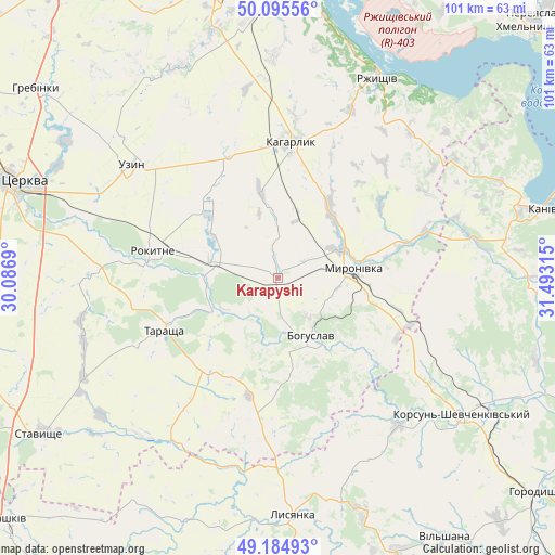
Karapyshi GPS coordinates[2]
49° 38' 32.532" North, 30° 47' 24.072" East
| Map corner | latitude | longitude |
|---|---|---|
| Upper-left | 50.09556°, | 30.0869° |
| Center: | 49.64237°, | 30.79002° |
| Lower-right: | 49.18493°, | 31.49315° |
| Map W x H: | 101.3×101.3 km | = 62.9×62.9mi |
| max Lat: | 52.18903° ⇑23.2% North |
| Karapyshi: | 49.64237° |
| min Lat: | ⇓76.8% South 44.39214° |
| min Long | Karapyshi | max Long |
| 22.20555° | 30.79002° | 40.13222° |
| W 37.2%⇐ | ⇒62.8% E |
Elevation
Elevation of Karapyshi is 146 m = 479 ft, and this is 9.8 m = 32 ft below average elevation for this country.
| Max E: |
886 m = 2907 ft | 46.7% |
| Avg. | 155.8 m = 511 ft | |
| Karapyshi | 146 m = 479 ft | |
Min E: |
-3 m = -10 ft | 53.3% |
See also: Ukraine elevation on elevation.city.
Geographical zone
Karapyshi is located in North temperate zone (between Tropic of Cancer and the Arctic Circle). Distance of this North polar circle is 1881.5 km =1169.1 mi to North.| Distance of | km | miles | from Karapyshi |
|---|---|---|---|
| North Pole | 4487.3 | 2788.3 | to North |
| Arctic Circle | 1881.5 | 1169.1 | to North |
| Tropic Cancer | 2913.8 | 1810.6 | to South |
| Equator | 5519.7 | 3429.8 | to South |


Nearby cities:
15 places around Karapyshi: (largest is in red/bold)
• Bohuslav
12 km =7.5 mi,  149°
149°
• Kaharlyk
24.6 km =15.3 mi,  6°
6°
• Kalynove
37.9 km =23.5 mi,  220°
220°
• Kaniv
49.7 km =30.9 mi,  75°
75°
• Korsun-Shevchenkivskyi
42 km =26.1 mi,  126°
126°
• Lysianka
43.5 km =27 mi,  176°
176°
• Mirovka
34.3 km =21.3 mi,  339°
339°
• Myronivka
14 km =8.7 mi, 81°
• Rokytne
23.3 km =14.5 mi,  282°
282°
• Rzhyshchiv
40.7 km =25.3 mi,  26°
26°
• Stavyshche
51.5 km =32 mi,  237°
237°
• Stayki
49.1 km =30.5 mi, 9°
• Stebliv
34.8 km =21.6 mi,  140°
140°
• Tarashcha
23.4 km =14.5 mi,  246°
246°
• Uzyn
33.8 km =21 mi,  307°
307°
Sources, notices
• [Note1] Compared only with cities in Ukraine existing in our database
• [Src1] Map data: © OpenStreetMap contributors (CC-BY-SA)
• [Src2] Other city data from geonames.org with taken over terms of usage.
• [Src3] Geographical zone / Annual Mean Temperature by Robert A. Rohde @ Wikipedia
