Alchevs’k geodata
Alchevs’k (Luhansk) is a populated place; located in Ukraine in Europe/Zaporozhye (GMT+3) time zone. With population of 116,000 people, there are 40 cities with bigger population in this country. Compared to other cities in Ukraine, 54.7% of cities are located further ↓South; 97.9% of cities are located further ←West and 71.2% of cities have lower elevation than Alchevs’k. Note1


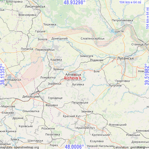
Alchevs’k GPS coordinates[2]
48° 28' 8.148" North, 38° 49' 0.084" East
| Map corner | latitude | longitude |
|---|---|---|
| Upper-left | 48.93298°, | 38.11357° |
| Center: | 48.46893°, | 38.81669° |
| Lower-right: | 48.0006°, | 39.51982° |
| Map W x H: | 103.7×103.7 km | = 64.4×64.4mi |
| max Lat: | 52.18903° ⇑45.3% North |
| Alchevs’k: | 48.46893° |
| min Lat: | ⇓54.7% South 44.39214° |
| min Long | Alchevs’k | max Long |
| 22.20555° | 38.81669° | 40.13222° |
| W 97.9%⇐ | ⇒2.1% E |
Elevation
Elevation of Alchevs’k is 211 m = 692 ft, and this is 55.2 m = 181 ft above average elevation for this country.
| Max E: |
886 m = 2907 ft | 28.8% |
| Alchevs’k | 211 m 692 ft | |
| Avg. | 155.8 m = 511 ft | |
Min E: |
-3 m = -10 ft | 71.2% |
See also: Alchevs’k elevation on elevation.city.
Geographical zone
Alchevs’k is located in North temperate zone (between Tropic of Cancer and the Arctic Circle). Distance of this North polar circle is 2011.9 km =1250.1 mi to North.| Distance of | km | miles | from Alchevs’k |
|---|---|---|---|
| North Pole | 4617.8 | 2869.4 | to North |
| Arctic Circle | 2011.9 | 1250.1 | to North |
| Tropic Cancer | 2783.3 | 1729.5 | to South |
| Equator | 5389.2 | 3348.7 | to South |


Nearby cities:
15 places around Alchevs’k: (largest is in red/bold)
• Artemivs’k
7 km =4.3 mi,  243°
243°
• Bayrachky
18 km =11.2 mi, 241°
• Bile
17.5 km =10.9 mi,  80°
80°
• Bryanka
11.6 km =7.2 mi,  293°
293°
• Chornukhyne
27.1 km =16.8 mi,  233°
233°
• Kadiyivka
16.9 km =10.5 mi,  310°
310°
• Kirovs’k
22.7 km =14.1 mi,  325°
325°
• Krasnyy Kut
29.8 km =18.5 mi,  182°
182°
• Lenina
24.6 km =15.3 mi,  100°
100°
• Pereval’s’k
4 km =2.5 mi,  149°
149°
• Pervomays’k
26.7 km =16.6 mi, 312°
• Slov`yanoserbsk
28.2 km =17.5 mi,  25°
25°
• Uspenka
27 km =16.8 mi,  108°
108°
• Zoryns’k
15.6 km =9.7 mi,  246°
246°
• Zymohiria
15.7 km =9.8 mi, 34°
Sources, notices
• [Note1] Compared only with cities in Ukraine existing in our database
• [Src1] Map data: © OpenStreetMap contributors (CC-BY-SA)
• [Src2] Other city data from geonames.org with taken over terms of usage.
• [Src3] Geographical zone / Annual Mean Temperature by Robert A. Rohde @ Wikipedia
