Pereval’s’k geodata
Pereval’s’k (Luhansk) is a seat of a second-order administrative division; located in Ukraine in Europe/Zaporozhye (GMT+3) time zone. With population of 29,220 people, there are 144 cities with bigger population in this country. Compared to other cities in Ukraine, 53.6% of cities are located further ↓South; 98% of cities are located further ←West and 75% of cities have lower elevation than Pereval’s’k. Note1


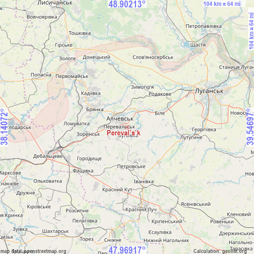
Pereval’s’k GPS coordinates[2]
48° 26' 16.044" North, 38° 50' 37.824" East
| Map corner | latitude | longitude |
|---|---|---|
| Upper-left | 48.90213°, | 38.14072° |
| Center: | 48.43779°, | 38.84384° |
| Lower-right: | 47.96917°, | 39.54697° |
| Map W x H: | 103.7×103.7 km | = 64.4×64.4mi |
| max Lat: | 52.18903° ⇑46.4% North |
| Pereval’s’k: | 48.43779° |
| min Lat: | ⇓53.6% South 44.39214° |
| min Long | Pereval’s’k | max Long |
| 22.20555° | 38.84384° | 40.13222° |
| W 98%⇐ | ⇒2% E |
Elevation
Elevation of Pereval’s’k is 227 m = 745 ft, and this is 71.2 m = 234 ft above average elevation for this country.
| Max E: |
886 m = 2907 ft | 25% |
| Pereval’s’k | 227 m 745 ft | |
| Avg. | 155.8 m = 511 ft | |
Min E: |
-3 m = -10 ft | 75% |
See also: Ukraine elevation on elevation.city.
Geographical zone
Pereval’s’k is located in North temperate zone (between Tropic of Cancer and the Arctic Circle). Distance of this North polar circle is 2015.4 km =1252.3 mi to North.| Distance of | km | miles | from Pereval’s’k |
|---|---|---|---|
| North Pole | 4621.3 | 2871.5 | to North |
| Arctic Circle | 2015.4 | 1252.3 | to North |
| Tropic Cancer | 2779.9 | 1727.3 | to South |
| Equator | 5385.8 | 3346.6 | to South |


Nearby cities:
15 places around Pereval’s’k: (largest is in red/bold)
• Alchevs’k
4 km =2.5 mi,  329°
329°
• Artemivs’k
8.3 km =5.2 mi,  272°
272°
• Bayrachky
18.6 km =11.6 mi,  254°
254°
• Bile
16.5 km =10.3 mi,  67°
67°
• Bryanka
15 km =9.3 mi,  302°
302°
• Chornukhyne
26.9 km =16.7 mi,  241°
241°
• Kadiyivka
20.7 km =12.9 mi,  314°
314°
• Kirovs’k
26.7 km =16.6 mi, 326°
• Krasnyy Kut
26.5 km =16.5 mi,  187°
187°
• Lenina
22.3 km =13.9 mi,  92°
92°
• Lutuhyne
28.5 km =17.7 mi,  97°
97°
• Pervomays’k
30.5 km =19 mi, 314°
• Uspenka
24.1 km =15 mi, 102°
• Zoryns’k
16.5 km =10.3 mi,  259°
259°
• Zymohiria
17.8 km =11.1 mi,  22°
22°
Sources, notices
• [Note1] Compared only with cities in Ukraine existing in our database
• [Src1] Map data: © OpenStreetMap contributors (CC-BY-SA)
• [Src2] Other city data from geonames.org with taken over terms of usage.
• [Src3] Geographical zone / Annual Mean Temperature by Robert A. Rohde @ Wikipedia
