Lykhivka geodata
Lykhivka (Dnipropetrovsk) is a populated place; located in Ukraine in Europe/Kiev (GMT+3) time zone. With population of 2,382 people, there are 1048 cities with bigger population in this country. Compared to other cities in Ukraine, 60.2% of cities are located further ↓South; 60.7% of cities are located further ←West and 71.1% of cities have higher elevation than Lykhivka. Note1


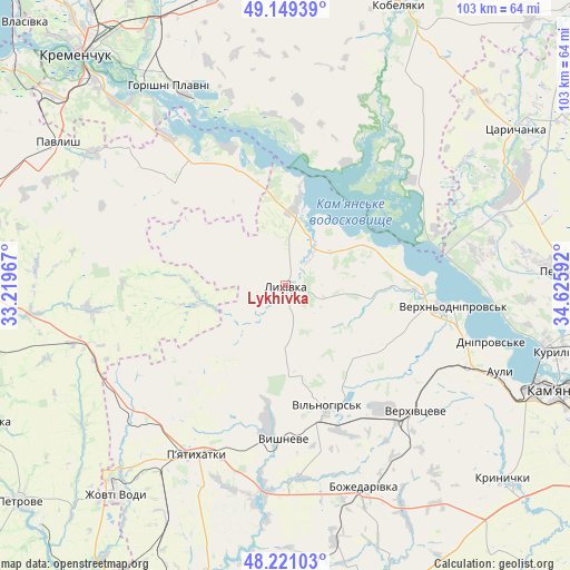
Lykhivka GPS coordinates[2]
48° 41' 14.46" North, 33° 55' 22.044" East
| Map corner | latitude | longitude |
|---|---|---|
| Upper-left | 49.14939°, | 33.21967° |
| Center: | 48.68735°, | 33.92279° |
| Lower-right: | 48.22103°, | 34.62592° |
| Map W x H: | 103.2×103.2 km | = 64.1×64.1mi |
| max Lat: | 52.18903° ⇑39.8% North |
| Lykhivka: | 48.68735° |
| min Lat: | ⇓60.2% South 44.39214° |
| min Long | Lykhivka | max Long |
| 22.20555° | 33.92279° | 40.13222° |
| W 60.7%⇐ | ⇒39.3% E |
Elevation
Elevation of Lykhivka is 72 m = 236 ft, and this is 83.8 m = 275 ft below average elevation for this country.
| Max E: |
886 m = 2907 ft | 71.1% |
| Avg. | 155.8 m = 511 ft | |
| Lykhivka | 72 m = 236 ft | |
Min E: |
-3 m = -10 ft | 28.9% |
See also: Ukraine elevation on elevation.city.
Geographical zone
Lykhivka is located in North temperate zone (between Tropic of Cancer and the Arctic Circle). Distance of this North polar circle is 1987.6 km =1235 mi to North.| Distance of | km | miles | from Lykhivka |
|---|---|---|---|
| North Pole | 4593.5 | 2854.3 | to North |
| Arctic Circle | 1987.6 | 1235 | to North |
| Tropic Cancer | 2807.6 | 1744.6 | to South |
| Equator | 5413.5 | 3363.8 | to South |


Nearby cities:
15 places around Lykhivka: (largest is in red/bold)
• Auly
41.8 km =26 mi,  108°
108°
• Horishni Plavni
41.6 km =25.8 mi,  329°
329°
• Kamennyye Potoki
43.6 km =27.1 mi,  318°
318°
• Kamianske
53.6 km =33.3 mi, 111°
• Kobelyaky
55.1 km =34.2 mi,  21°
21°
• Krynychky
53 km =32.9 mi,  130°
130°
• Novomykolayivka
36.2 km =22.5 mi, 113°
• Onufriyivka
42.5 km =26.4 mi,  305°
305°
• Pavlysh
48.7 km =30.3 mi,  301°
301°
• Petrykivka
52.4 km =32.6 mi,  84°
84°
• Piatykhatky
34.2 km =21.3 mi,  207°
207°
• Tsarychanka
49.3 km =30.6 mi,  55°
55°
• Verkhn’odniprovs’k
30.5 km =19 mi,  97°
97°
• Vyshneve
27.9 km =17.3 mi,  181°
181°
• Zhovti Vody
49 km =30.4 mi,  219°
219°
Sources, notices
• [Note1] Compared only with cities in Ukraine existing in our database
• [Src1] Map data: © OpenStreetMap contributors (CC-BY-SA)
• [Src2] Other city data from geonames.org with taken over terms of usage.
• [Src3] Geographical zone / Annual Mean Temperature by Robert A. Rohde @ Wikipedia
