Piatykhatky geodata
Piatykhatky (Dnipropetrovsk) is a populated place; located in Ukraine in Europe/Kiev (GMT+3) time zone. With population of 20,459 people, there are 196 cities with bigger population in this country. Compared to other cities in Ukraine, 53.1% of cities are located further ↓South; 55.8% of cities are located further ←West and 60.1% of cities have lower elevation than Piatykhatky. Note1


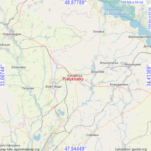
Piatykhatky GPS coordinates[2]
48° 24' 47.988" North, 33° 42' 38.016" East
| Map corner | latitude | longitude |
|---|---|---|
| Upper-left | 48.87789°, | 33.00744° |
| Center: | 48.41333°, | 33.71056° |
| Lower-right: | 47.94449°, | 34.41369° |
| Map W x H: | 103.8×103.8 km | = 64.5×64.5mi |
| max Lat: | 52.18903° ⇑46.9% North |
| Piatykhatky: | 48.41333° |
| min Lat: | ⇓53.1% South 44.39214° |
| min Long | Piatykhatky | max Long |
| 22.20555° | 33.71056° | 40.13222° |
| W 55.8%⇐ | ⇒44.2% E |
Elevation
Elevation of Piatykhatky is 169 m = 554 ft, and this is 13.2 m = 43 ft above average elevation for this country.
| Max E: |
886 m = 2907 ft | 39.9% |
| Piatykhatky | 169 m 554 ft | |
| Avg. | 155.8 m = 511 ft | |
Min E: |
-3 m = -10 ft | 60.1% |
See also: Ukraine elevation on elevation.city.
Geographical zone
Piatykhatky is located in North temperate zone (between Tropic of Cancer and the Arctic Circle). Distance of this North polar circle is 2018.1 km =1254 mi to North.| Distance of | km | miles | from Piatykhatky |
|---|---|---|---|
| North Pole | 4624 | 2873.2 | to North |
| Arctic Circle | 2018.1 | 1254 | to North |
| Tropic Cancer | 2777.1 | 1725.6 | to South |
| Equator | 5383.1 | 3344.9 | to South |


Nearby cities:
15 places around Piatykhatky: (largest is in red/bold)
• Auly
57.9 km =36 mi,  72°
72°
• Krynychky
56 km =34.8 mi,  94°
94°
• Lozuvatka
50.6 km =31.4 mi,  218°
218°
• Lykhivka
34.2 km =21.3 mi,  27°
27°
• Novomykolayivka
51.4 km =31.9 mi, 71°
• Novyy Starodub
41.2 km =25.6 mi,  286°
286°
• Oleksandriya
52.2 km =32.4 mi,  303°
303°
• Oleksandriys’ke
57.8 km =35.9 mi, 291°
• Onufriyivka
58.2 km =36.2 mi,  340°
340°
• Petrove
35 km =21.7 mi,  253°
253°
• Pryyutivka
58.2 km =36.2 mi,  306°
306°
• Sofiyivka
42.4 km =26.3 mi,  163°
163°
• Verkhn’odniprovs’k
53.1 km =33 mi,  59°
59°
• Vyshneve
15.3 km =9.5 mi,  80°
80°
• Zhovti Vody
17.1 km =10.6 mi,  243°
243°
In other languages:
- In Spanish: Piatyjatky
- In German: Pjatychatky
- In Russian: Пятихатки
- In Chinese: 皮亞季哈特基
Sources, notices
• [Note1] Compared only with cities in Ukraine existing in our database
• [Src1] Map data: © OpenStreetMap contributors (CC-BY-SA)
• [Src2] Other city data from geonames.org with taken over terms of usage.
• [Src3] Geographical zone / Annual Mean Temperature by Robert A. Rohde @ Wikipedia
