Kotel’va geodata
Kotel’va (Poltava) is a seat of a second-order administrative division; located in Ukraine in Europe/Kiev (GMT+3) time zone. With population of 12,660 people, there are 294 cities with bigger population in this country. Compared to other cities in Ukraine, 84.8% of cities are located further ↓South; 77.3% of cities are located further ←West and 62.1% of cities have higher elevation than Kotel’va. Note1


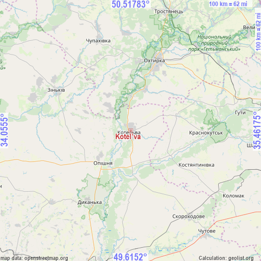
Kotel’va GPS coordinates[2]
50° 4' 7.104" North, 34° 45' 31.032" East
| Map corner | latitude | longitude |
|---|---|---|
| Upper-left | 50.51783°, | 34.0555° |
| Center: | 50.06864°, | 34.75862° |
| Lower-right: | 49.6152°, | 35.46175° |
| Map W x H: | 100.4×100.4 km | = 62.4×62.4mi |
| max Lat: | 52.18903° ⇑15.2% North |
| Kotel’va: | 50.06864° |
| min Lat: | ⇓84.8% South 44.39214° |
| min Long | Kotel’va | max Long |
| 22.20555° | 34.75862° | 40.13222° |
| W 77.3%⇐ | ⇒22.7% E |
Elevation
Elevation of Kotel’va is 100 m = 328 ft, and this is 55.8 m = 183 ft below average elevation for this country.
| Max E: |
886 m = 2907 ft | 62.1% |
| Avg. | 155.8 m = 511 ft | |
| Kotel’va | 100 m = 328 ft | |
Min E: |
-3 m = -10 ft | 37.9% |
See also: Ukraine elevation on elevation.city.
Geographical zone
Kotel’va is located in North temperate zone (between Tropic of Cancer and the Arctic Circle). Distance of this North polar circle is 1834.1 km =1139.7 mi to North.| Distance of | km | miles | from Kotel’va |
|---|---|---|---|
| North Pole | 4440 | 2758.9 | to North |
| Arctic Circle | 1834.1 | 1139.7 | to North |
| Tropic Cancer | 2961.2 | 1840 | to South |
| Equator | 5567.1 | 3459.2 | to South |


Nearby cities:
15 places around Kotel’va: (largest is in red/bold)
• Bohodukhiv
55.9 km =34.7 mi,  78°
78°
• Chutove
49.4 km =30.7 mi,  143°
143°
• Dykan’ka
31.7 km =19.7 mi,  211°
211°
• Huty
42.4 km =26.3 mi, 80°
• Kolomak
46.6 km =29 mi,  123°
123°
• Krasnokuts’k
28.8 km =17.9 mi,  90°
90°
• Kyrykivka
41.5 km =25.8 mi,  37°
37°
• Lebedyn
60.6 km =37.7 mi,  341°
341°
• Okhtyrka
28.7 km =17.8 mi,  20°
20°
• Oposhnya
16.3 km =10.1 mi,  219°
219°
• Poltava
55.1 km =34.2 mi,  196°
196°
• Shyshaky
57.3 km =35.6 mi,  248°
248°
• Trostyanets’
48.6 km =30.2 mi, 17°
• Velyki Sorochyntsi
58.6 km =36.4 mi,  265°
265°
• Zin’kiv
32.1 km =19.9 mi,  298°
298°
Sources, notices
• [Note1] Compared only with cities in Ukraine existing in our database
• [Src1] Map data: © OpenStreetMap contributors (CC-BY-SA)
• [Src2] Other city data from geonames.org with taken over terms of usage.
• [Src3] Geographical zone / Annual Mean Temperature by Robert A. Rohde @ Wikipedia
