Chutove geodata
Chutove (Poltava) is a seat of a second-order administrative division; located in Ukraine in Europe/Kiev (GMT+3) time zone. With population of 6,274 people, there are 551 cities with bigger population in this country. Compared to other cities in Ukraine, 78.1% of cities are located further ↓South; 82.2% of cities are located further ←West and 61.4% of cities have higher elevation than Chutove. Note1


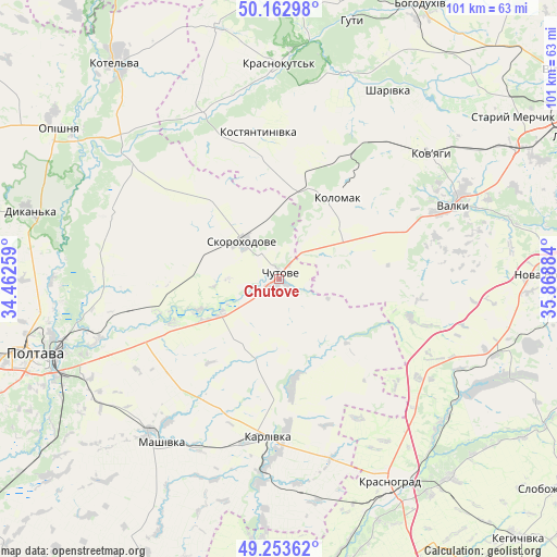
Chutove GPS coordinates[2]
49° 42' 37.548" North, 35° 9' 56.556" East
| Map corner | latitude | longitude |
|---|---|---|
| Upper-left | 50.16298°, | 34.46259° |
| Center: | 49.71043°, | 35.16571° |
| Lower-right: | 49.25362°, | 35.86884° |
| Map W x H: | 101.1×101.1 km | = 62.8×62.8mi |
| max Lat: | 52.18903° ⇑21.9% North |
| Chutove: | 49.71043° |
| min Lat: | ⇓78.1% South 44.39214° |
| min Long | Chutove | max Long |
| 22.20555° | 35.16571° | 40.13222° |
| W 82.2%⇐ | ⇒17.8% E |
Elevation
Elevation of Chutove is 101 m = 331 ft, and this is 54.8 m = 180 ft below average elevation for this country.
| Max E: |
886 m = 2907 ft | 61.4% |
| Avg. | 155.8 m = 511 ft | |
| Chutove | 101 m = 331 ft | |
Min E: |
-3 m = -10 ft | 38.6% |
See also: Ukraine elevation on elevation.city.
Geographical zone
Chutove is located in North temperate zone (between Tropic of Cancer and the Arctic Circle). Distance of this North polar circle is 1873.9 km =1164.4 mi to North.| Distance of | km | miles | from Chutove |
|---|---|---|---|
| North Pole | 4479.8 | 2783.6 | to North |
| Arctic Circle | 1873.9 | 1164.4 | to North |
| Tropic Cancer | 2921.4 | 1815.3 | to South |
| Equator | 5527.3 | 3434.5 | to South |


Nearby cities:
15 places around Chutove: (largest is in red/bold)
• Berezivka
49.3 km =30.6 mi,  127°
127°
• Dykan’ka
47.5 km =29.5 mi,  285°
285°
• Huty
48.7 km =30.3 mi,  15°
15°
• Karlivka
28.3 km =17.6 mi,  185°
185°
• Kolomak
17.5 km =10.9 mi,  34°
34°
• Kotel’va
49.4 km =30.7 mi,  323°
323°
• Krasnohrad
41.8 km =26 mi,  151°
151°
• Krasnokuts’k
39.5 km =24.5 mi,  359°
359°
• Mashivka
36.7 km =22.8 mi,  215°
215°
• Oposhnya
48.2 km =30 mi,  304°
304°
• Poltava
46.8 km =29.1 mi,  253°
253°
• Shlyakh
49 km =30.4 mi,  60°
60°
• Valky
35 km =21.7 mi,  66°
66°
• Varvarivka
19.4 km =12.1 mi,  172°
172°
• Verbivka
42.1 km =26.2 mi,  140°
140°
Sources, notices
• [Note1] Compared only with cities in Ukraine existing in our database
• [Src1] Map data: © OpenStreetMap contributors (CC-BY-SA)
• [Src2] Other city data from geonames.org with taken over terms of usage.
• [Src3] Geographical zone / Annual Mean Temperature by Robert A. Rohde @ Wikipedia
