Trostyanets’ geodata
Trostyanets’ (Sumy) is a seat of a second-order administrative division; located in Ukraine in Europe/Kiev (GMT+3) time zone. With population of 8,151 people, there are 435 cities with bigger population in this country. Compared to other cities in Ukraine, 90.6% of cities are located further ↓South; 79.9% of cities are located further ←West and 54.9% of cities have higher elevation than Trostyanets’. Note1


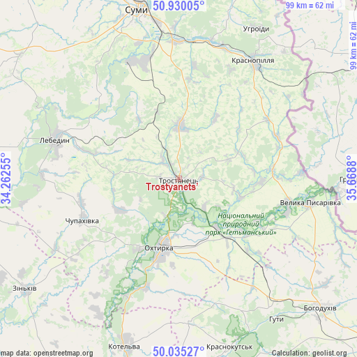
Trostyanets’ GPS coordinates[2]
50° 29' 5.208" North, 34° 57' 56.412" East
| Map corner | latitude | longitude |
|---|---|---|
| Upper-left | 50.93005°, | 34.26255° |
| Center: | 50.48478°, | 34.96567° |
| Lower-right: | 50.03527°, | 35.6688° |
| Map W x H: | 99.5×99.5 km | = 61.8×61.8mi |
| max Lat: | 52.18903° ⇑9.4% North |
| Trostyanets’: | 50.48478° |
| min Lat: | ⇓90.6% South 44.39214° |
| min Long | Trostyanets’ | max Long |
| 22.20555° | 34.96567° | 40.13222° |
| W 79.9%⇐ | ⇒20.1% E |
Elevation
Elevation of Trostyanets’ is 120 m = 394 ft, and this is 35.8 m = 117 ft below average elevation for this country.
| Max E: |
886 m = 2907 ft | 54.9% |
| Avg. | 155.8 m = 511 ft | |
| Trostyanets’ | 120 m = 394 ft | |
Min E: |
-3 m = -10 ft | 45.1% |
See also: Ukraine elevation on elevation.city.
Geographical zone
Trostyanets’ is located in North temperate zone (between Tropic of Cancer and the Arctic Circle). Distance of this North polar circle is 1787.8 km =1110.9 mi to North.| Distance of | km | miles | from Trostyanets’ |
|---|---|---|---|
| North Pole | 4393.7 | 2730.1 | to North |
| Arctic Circle | 1787.8 | 1110.9 | to North |
| Tropic Cancer | 3007.5 | 1868.8 | to South |
| Equator | 5613.4 | 3488 | to South |


Nearby cities:
15 places around Trostyanets’: (largest is in red/bold)
• Bohodukhiv
53.5 km =33.2 mi,  131°
131°
• Boromlya
14.9 km =9.3 mi,  1°
1°
• Huty
47.4 km =29.5 mi,  145°
145°
• Kotel’va
48.6 km =30.2 mi,  197°
197°
• Krasnokuts’k
48.6 km =30.2 mi,  163°
163°
• Krasnopillya
38.3 km =23.8 mi,  32°
32°
• Kyrykivka
17.1 km =10.6 mi,  141°
141°
• Lebedyn
35.8 km =22.2 mi,  288°
288°
• Mezenivka
29.7 km =18.5 mi,  55°
55°
• Nyzy
35.5 km =22.1 mi,  338°
338°
• Okhtyrka
20 km =12.4 mi,  193°
193°
• Sumy
49.9 km =31 mi,  346°
346°
• Velyka Pysarivka
37 km =23 mi,  100°
100°
• Verkhnya Syrovatka
38.3 km =23.8 mi,  359°
359°
• Zin’kiv
52.6 km =32.7 mi,  234°
234°
Sources, notices
• [Note1] Compared only with cities in Ukraine existing in our database
• [Src1] Map data: © OpenStreetMap contributors (CC-BY-SA)
• [Src2] Other city data from geonames.org with taken over terms of usage.
• [Src3] Geographical zone / Annual Mean Temperature by Robert A. Rohde @ Wikipedia
