Dykan’ka geodata
Dykan’ka (Poltava) is a seat of a second-order administrative division; located in Ukraine in Europe/Kiev (GMT+3) time zone. With population of 8,000 people, there are 446 cities with bigger population in this country. Compared to other cities in Ukraine, 80.1% of cities are located further ↓South; 73.6% of cities are located further ←West and 59.7% of cities have lower elevation than Dykan’ka. Note1


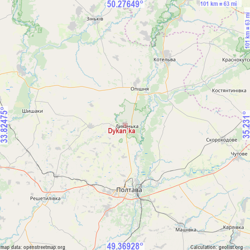
Dykan’ka GPS coordinates[2]
49° 49' 30.036" North, 34° 31' 40.332" East
| Map corner | latitude | longitude |
|---|---|---|
| Upper-left | 50.27649°, | 33.82475° |
| Center: | 49.82501°, | 34.52787° |
| Lower-right: | 49.36928°, | 35.231° |
| Map W x H: | 100.9×100.9 km | = 62.7×62.7mi |
| max Lat: | 52.18903° ⇑19.9% North |
| Dykan’ka: | 49.82501° |
| min Lat: | ⇓80.1% South 44.39214° |
| min Long | Dykan’ka | max Long |
| 22.20555° | 34.52787° | 40.13222° |
| W 73.6%⇐ | ⇒26.4% E |
Elevation
Elevation of Dykan’ka is 168 m = 551 ft, and this is 12.2 m = 40 ft above average elevation for this country.
| Max E: |
886 m = 2907 ft | 40.3% |
| Dykan’ka | 168 m 551 ft | |
| Avg. | 155.8 m = 511 ft | |
Min E: |
-3 m = -10 ft | 59.7% |
See also: Ukraine elevation on elevation.city.
Geographical zone
Dykan’ka is located in North temperate zone (between Tropic of Cancer and the Arctic Circle). Distance of this North polar circle is 1861.2 km =1156.5 mi to North.| Distance of | km | miles | from Dykan’ka |
|---|---|---|---|
| North Pole | 4467 | 2775.7 | to North |
| Arctic Circle | 1861.2 | 1156.5 | to North |
| Tropic Cancer | 2934.1 | 1823.2 | to South |
| Equator | 5540 | 3442.4 | to South |


Nearby cities:
15 places around Dykan’ka: (largest is in red/bold)
• Chutove
47.5 km =29.5 mi,  105°
105°
• Karlivka
59.6 km =37 mi,  133°
133°
• Kolomak
55.7 km =34.6 mi,  88°
88°
• Kotel’va
31.7 km =19.7 mi,  31°
31°
• Krasnokuts’k
52.7 km =32.7 mi,  59°
59°
• Mashivka
49 km =30.4 mi,  150°
150°
• Novi Sanzhary
55.7 km =34.6 mi,  196°
196°
• Oposhnya
15.8 km =9.8 mi,  22°
22°
• Poltava
25.7 km =16 mi,  177°
177°
• Reshetylivka
43.4 km =27 mi,  228°
228°
• Shyshaky
37.6 km =23.4 mi,  279°
279°
• Varvarivka
58 km =36 mi,  123°
123°
• Velyka Bahachka
57.9 km =36 mi,  266°
266°
• Velyki Sorochyntsi
47.4 km =29.5 mi,  297°
297°
• Zin’kiv
44.2 km =27.5 mi,  344°
344°
Sources, notices
• [Note1] Compared only with cities in Ukraine existing in our database
• [Src1] Map data: © OpenStreetMap contributors (CC-BY-SA)
• [Src2] Other city data from geonames.org with taken over terms of usage.
• [Src3] Geographical zone / Annual Mean Temperature by Robert A. Rohde @ Wikipedia
