Kolomyia geodata
Kolomyia (Ivano-Frankivsk) is a seat of a second-order administrative division; located in Ukraine in Europe/Kiev (GMT+3) time zone. With population of 61,781 people, there are 78 cities with bigger population in this country. Compared to other cities in Ukraine, 56.1% of cities are located further ↓South; 85.7% of cities are located further →East and 87.3% of cities have lower elevation than Kolomyia. Note1


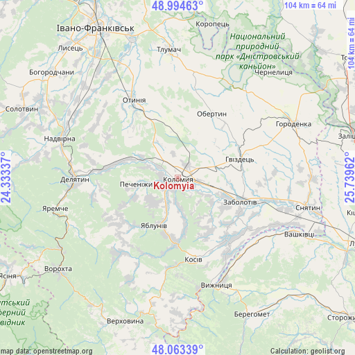
Kolomyia GPS coordinates[2]
48° 31' 52.14" North, 25° 2' 11.364" East
| Map corner | latitude | longitude |
|---|---|---|
| Upper-left | 48.99463°, | 24.33337° |
| Center: | 48.53115°, | 25.03649° |
| Lower-right: | 48.06339°, | 25.73962° |
| Map W x H: | 103.5×103.5 km | = 64.3×64.3mi |
| max Lat: | 52.18903° ⇑43.9% North |
| Kolomyia: | 48.53115° |
| min Lat: | ⇓56.1% South 44.39214° |
| min Long | Kolomyia | max Long |
| 22.20555° | 25.03649° | 40.13222° |
| W 14.3%⇐ | ⇒85.7% E |
Elevation
Elevation of Kolomyia is 289 m = 948 ft, and this is 133.2 m = 437 ft above average elevation for this country.
| Max E: |
886 m = 2907 ft | 12.7% |
| Kolomyia | 289 m 948 ft | |
| Avg. | 155.8 m = 511 ft | |
Min E: |
-3 m = -10 ft | 87.3% |
See also: Kolomyia elevation on elevation.city.
Geographical zone
Kolomyia is located in North temperate zone (between Tropic of Cancer and the Arctic Circle). Distance of this North polar circle is 2005 km =1245.8 mi to North.| Distance of | km | miles | from Kolomyia |
|---|---|---|---|
| North Pole | 4610.9 | 2865.1 | to North |
| Arctic Circle | 2005 | 1245.8 | to North |
| Tropic Cancer | 2790.2 | 1733.7 | to South |
| Equator | 5396.2 | 3353 | to South |


Nearby cities:
15 places around Kolomyia: (largest is in red/bold)
• Bili Oslavy
25.2 km =15.7 mi,  258°
258°
• Khymchyn
18.1 km =11.2 mi,  152°
152°
• Kosiv
24.9 km =15.5 mi,  169°
169°
• Kosmach
27.5 km =17.1 mi,  215°
215°
• Krasna
25.2 km =15.7 mi,  281°
281°
• Lanchyn
20.8 km =12.9 mi, 278°
• Obertyn
21.2 km =13.2 mi,  27°
27°
• Otyniya
26.3 km =16.3 mi,  330°
330°
• Pechenizhyn
10.6 km =6.6 mi, 260°
• Rozhniv
23.1 km =14.4 mi,  142°
142°
• Sadzhavka
18.7 km =11.6 mi, 281°
• Sheshory
22.5 km =14 mi,  190°
190°
• Velykyy Klyuchiv
9.4 km =5.8 mi, 224°
• Yabluniv
15.9 km =9.9 mi,  207°
207°
• Zabolotiv
19.6 km =12.2 mi,  110°
110°
Sources, notices
• [Note1] Compared only with cities in Ukraine existing in our database
• [Src1] Map data: © OpenStreetMap contributors (CC-BY-SA)
• [Src2] Other city data from geonames.org with taken over terms of usage.
• [Src3] Geographical zone / Annual Mean Temperature by Robert A. Rohde @ Wikipedia
