Rivne geodata
Rivne (Kirovohrad) is a populated place; located in Ukraine in Europe/Kiev (GMT+3) time zone. With population of 5,296 people, there are 622 cities with bigger population in this country. Compared to other cities in Ukraine, 51.2% of cities are located further ↑North; 58.3% of cities are located further →East and 54.6% of cities have lower elevation than Rivne. Note1


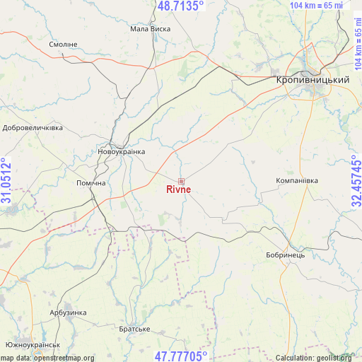
Rivne GPS coordinates[2]
48° 14' 50.712" North, 31° 45' 15.552" East
| Map corner | latitude | longitude |
|---|---|---|
| Upper-left | 48.7135°, | 31.0512° |
| Center: | 48.24742°, | 31.75432° |
| Lower-right: | 47.77705°, | 32.45745° |
| Map W x H: | 104.1×104.1 km | = 64.7×64.7mi |
| max Lat: | 52.18903° ⇑51.2% North |
| Rivne: | 48.24742° |
| min Lat: | ⇓48.8% South 44.39214° |
| min Long | Rivne | max Long |
| 22.20555° | 31.75432° | 40.13222° |
| W 41.7%⇐ | ⇒58.3% E |
Elevation
Elevation of Rivne is 151 m = 495 ft, and this is 4.8 m = 16 ft below average elevation for this country.
| Max E: |
886 m = 2907 ft | 45.4% |
| Avg. | 155.8 m = 511 ft | |
| Rivne | 151 m = 495 ft | |
Min E: |
-3 m = -10 ft | 54.6% |
See also: Ukraine elevation on elevation.city.
Geographical zone
Rivne is located in North temperate zone (between Tropic of Cancer and the Arctic Circle). Distance of this North polar circle is 2036.6 km =1265.5 mi to North.| Distance of | km | miles | from Rivne |
|---|---|---|---|
| North Pole | 4642.5 | 2884.7 | to North |
| Arctic Circle | 2036.6 | 1265.5 | to North |
| Tropic Cancer | 2758.7 | 1714.2 | to South |
| Equator | 5364.6 | 3333.4 | to South |


Nearby cities:
15 places around Rivne: (largest is in red/bold)
• Arbuzynka
49.5 km =30.8 mi,  220°
220°
• Bobrynets
37.1 km =23.1 mi,  124°
124°
• Brats’ke
44.5 km =27.7 mi,  196°
196°
• Dobrovelychkivka
45.2 km =28.1 mi,  290°
290°
• Kompaniyivka
33.6 km =20.9 mi,  89°
89°
• Kropyvnytskyi
47.6 km =29.6 mi,  51°
51°
• Lypnyazhka
54.8 km =34.1 mi, 293°
• Lysa Hora
48.5 km =30.1 mi,  259°
259°
• Mala Vyska
44.8 km =27.8 mi,  348°
348°
• Novomyrhorod
59.9 km =37.2 mi, 352°
• Novoukrayinka
18.9 km =11.7 mi,  297°
297°
• Pomichna
25.1 km =15.6 mi,  268°
268°
• Yelanets’
61.7 km =38.3 mi,  173°
173°
• Yuzhnoukrains'k
63.9 km =39.7 mi, 221°
• Zlynka
30.9 km =19.2 mi,  328°
328°
Sources, notices
• [Note1] Compared only with cities in Ukraine existing in our database
• [Src1] Map data: © OpenStreetMap contributors (CC-BY-SA)
• [Src2] Other city data from geonames.org with taken over terms of usage.
• [Src3] Geographical zone / Annual Mean Temperature by Robert A. Rohde @ Wikipedia
