Hupalivka geodata
Hupalivka (Dnipropetrovsk) is a populated place; located in Ukraine in Europe/Kiev (GMT+3) time zone. With population of 1,347 people, there are 1253 cities with bigger population in this country. Compared to other cities in Ukraine, 68.7% of cities are located further ↓South; 76.9% of cities are located further ←West and 69.8% of cities have higher elevation than Hupalivka. Note1


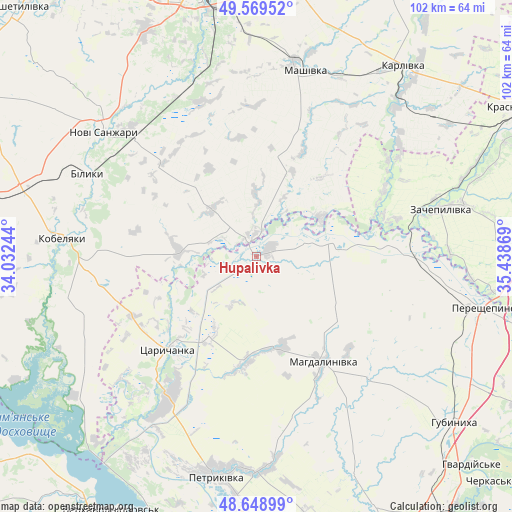
Hupalivka GPS coordinates[2]
49° 6' 41.004" North, 34° 44' 8.016" East
| Map corner | latitude | longitude |
|---|---|---|
| Upper-left | 49.56952°, | 34.03244° |
| Center: | 49.11139°, | 34.73556° |
| Lower-right: | 48.64899°, | 35.43869° |
| Map W x H: | 102.4×102.4 km | = 63.6×63.6mi |
| max Lat: | 52.18903° ⇑31.3% North |
| Hupalivka: | 49.11139° |
| min Lat: | ⇓68.7% South 44.39214° |
| min Long | Hupalivka | max Long |
| 22.20555° | 34.73556° | 40.13222° |
| W 76.9%⇐ | ⇒23.1% E |
Elevation
Elevation of Hupalivka is 76 m = 249 ft, and this is 79.8 m = 262 ft below average elevation for this country.
| Max E: |
886 m = 2907 ft | 69.8% |
| Avg. | 155.8 m = 511 ft | |
| Hupalivka | 76 m = 249 ft | |
Min E: |
-3 m = -10 ft | 30.2% |
See also: Ukraine elevation on elevation.city.
Geographical zone
Hupalivka is located in North temperate zone (between Tropic of Cancer and the Arctic Circle). Distance of this North polar circle is 1940.5 km =1205.8 mi to North.| Distance of | km | miles | from Hupalivka |
|---|---|---|---|
| North Pole | 4546.4 | 2825 | to North |
| Arctic Circle | 1940.5 | 1205.8 | to North |
| Tropic Cancer | 2854.8 | 1773.9 | to South |
| Equator | 5460.7 | 3393.1 | to South |


Nearby cities:
15 places around Hupalivka: (largest is in red/bold)
• Hubynykha
50.7 km =31.5 mi,  131°
131°
• Karlivka
47.9 km =29.8 mi,  36°
36°
• Kobelyaky
39.4 km =24.5 mi,  276°
276°
• Krasnohrad
59.3 km =36.8 mi,  59°
59°
• Mahdalynivka
24.9 km =15.5 mi,  148°
148°
• Mashivka
38.1 km =23.7 mi,  14°
14°
• Novi Sanzhary
40.2 km =25 mi,  309°
309°
• Partyzans’ke
58.6 km =36.4 mi,  174°
174°
• Petrykivka
43.1 km =26.8 mi,  189°
189°
• Poltava
55.5 km =34.5 mi,  345°
345°
• Spas’ke
54.6 km =33.9 mi, 154°
• Tsarychanka
27 km =16.8 mi,  224°
224°
• Varvarivka
58.2 km =36.2 mi, 35°
• Verkhn’odniprovs’k
58.9 km =36.6 mi,  209°
209°
• Zachepylivka
37.8 km =23.5 mi,  75°
75°
Sources, notices
• [Note1] Compared only with cities in Ukraine existing in our database
• [Src1] Map data: © OpenStreetMap contributors (CC-BY-SA)
• [Src2] Other city data from geonames.org with taken over terms of usage.
• [Src3] Geographical zone / Annual Mean Temperature by Robert A. Rohde @ Wikipedia
