Hradyz’k geodata
Hradyz’k (Poltava) is a populated place; located in Ukraine in Europe/Kiev (GMT+3) time zone. With population of 7,400 people, there are 483 cities with bigger population in this country. Compared to other cities in Ukraine, 70.4% of cities are located further ↓South; 51.9% of cities are located further →East and 65.2% of cities have higher elevation than Hradyz’k. Note1


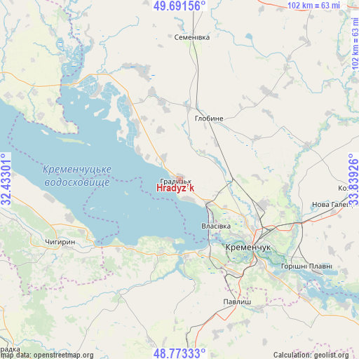
Hradyz’k GPS coordinates[2]
49° 14' 4.488" North, 33° 8' 10.068" East
| Map corner | latitude | longitude |
|---|---|---|
| Upper-left | 49.69156°, | 32.43301° |
| Center: | 49.23458°, | 33.13613° |
| Lower-right: | 48.77333°, | 33.83926° |
| Map W x H: | 102.1×102.1 km | = 63.4×63.4mi |
| max Lat: | 52.18903° ⇑29.6% North |
| Hradyz’k: | 49.23458° |
| min Lat: | ⇓70.4% South 44.39214° |
| min Long | Hradyz’k | max Long |
| 22.20555° | 33.13613° | 40.13222° |
| W 48.1%⇐ | ⇒51.9% E |
Elevation
Elevation of Hradyz’k is 89 m = 292 ft, and this is 66.8 m = 219 ft below average elevation for this country.
| Max E: |
886 m = 2907 ft | 65.2% |
| Avg. | 155.8 m = 511 ft | |
| Hradyz’k | 89 m = 292 ft | |
Min E: |
-3 m = -10 ft | 34.8% |
See also: Ukraine elevation on elevation.city.
Geographical zone
Hradyz’k is located in North temperate zone (between Tropic of Cancer and the Arctic Circle). Distance of this North polar circle is 1926.8 km =1197.3 mi to North.| Distance of | km | miles | from Hradyz’k |
|---|---|---|---|
| North Pole | 4532.7 | 2816.5 | to North |
| Arctic Circle | 1926.8 | 1197.3 | to North |
| Tropic Cancer | 2868.5 | 1782.4 | to South |
| Equator | 5474.4 | 3401.6 | to South |


Nearby cities:
15 places around Hradyz’k: (largest is in red/bold)
• Chyhyryn
38.8 km =24.1 mi,  244°
244°
• Dmytrivka
57.5 km =35.7 mi,  212°
212°
• Hlobyne
19.2 km =11.9 mi,  27°
27°
• Horishni Plavni
44.1 km =27.4 mi,  124°
124°
• Kamennyye Potoki
40.1 km =24.9 mi,  134°
134°
• Khorol
61.9 km =38.5 mi,  9°
9°
• Kozel’shchyna
51.7 km =32.1 mi,  92°
92°
• Kremenchuk
27.8 km =17.3 mi, 131°
• Lutovynivka
55.8 km =34.7 mi, 89°
• Oleksandriya
62.8 km =39 mi,  181°
181°
• Onufriyivka
42.9 km =26.7 mi,  147°
147°
• Pavlysh
38.7 km =24 mi,  155°
155°
• Pryyutivka
57.3 km =35.6 mi, 184°
• Semenivka
39.7 km =24.7 mi,  4°
4°
• Svitlovods’k
22 km =13.7 mi, 159°
Sources, notices
• [Note1] Compared only with cities in Ukraine existing in our database
• [Src1] Map data: © OpenStreetMap contributors (CC-BY-SA)
• [Src2] Other city data from geonames.org with taken over terms of usage.
• [Src3] Geographical zone / Annual Mean Temperature by Robert A. Rohde @ Wikipedia
