Chyhyryn geodata
Chyhyryn (Cherkasy) is a populated place; located in Ukraine in Europe/Kiev (GMT+3) time zone. With population of 11,515 people, there are 320 cities with bigger population in this country. Compared to other cities in Ukraine, 68.1% of cities are located further ↓South; 54.6% of cities are located further →East and 69.8% of cities have higher elevation than Chyhyryn. Note1


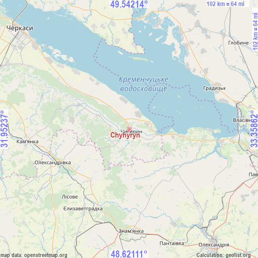
Chyhyryn GPS coordinates[2]
49° 5' 1.536" North, 32° 39' 19.764" East
| Map corner | latitude | longitude |
|---|---|---|
| Upper-left | 49.54214°, | 31.95237° |
| Center: | 49.08376°, | 32.65549° |
| Lower-right: | 48.62111°, | 33.35862° |
| Map W x H: | 102.4×102.4 km | = 63.6×63.6mi |
| max Lat: | 52.18903° ⇑31.9% North |
| Chyhyryn: | 49.08376° |
| min Lat: | ⇓68.1% South 44.39214° |
| min Long | Chyhyryn | max Long |
| 22.20555° | 32.65549° | 40.13222° |
| W 45.4%⇐ | ⇒54.6% E |
Elevation
Elevation of Chyhyryn is 76 m = 249 ft, and this is 79.8 m = 262 ft below average elevation for this country.
| Max E: |
886 m = 2907 ft | 69.8% |
| Avg. | 155.8 m = 511 ft | |
| Chyhyryn | 76 m = 249 ft | |
Min E: |
-3 m = -10 ft | 30.2% |
See also: Ukraine elevation on elevation.city.
Geographical zone
Chyhyryn is located in North temperate zone (between Tropic of Cancer and the Arctic Circle). Distance of this North polar circle is 1943.6 km =1207.7 mi to North.| Distance of | km | miles | from Chyhyryn |
|---|---|---|---|
| North Pole | 4549.5 | 2826.9 | to North |
| Arctic Circle | 1943.6 | 1207.7 | to North |
| Tropic Cancer | 2851.7 | 1772 | to South |
| Equator | 5457.6 | 3391.2 | to South |


Nearby cities:
15 places around Chyhyryn: (largest is in red/bold)
• Chervona Sloboda
48.4 km =30.1 mi,  311°
311°
• Dmytrivka
32.2 km =20 mi,  172°
172°
• Hlobyne
55.4 km =34.4 mi,  52°
52°
• Hradyz’k
38.8 km =24.1 mi,  64°
64°
• Kamianka
40.6 km =25.2 mi,  261°
261°
• Kremenchuk
55.7 km =34.6 mi,  91°
91°
• Oleksandrivka
33.5 km =20.8 mi,  246°
246°
• Oleksandriya
57 km =35.4 mi,  143°
143°
• Pantayivka
48.5 km =30.1 mi,  159°
159°
• Pavlysh
54.4 km =33.8 mi,  109°
109°
• Pryyutivka
50.5 km =31.4 mi, 143°
• Subottsi
48.6 km =30.2 mi,  191°
191°
• Svitlovods’k
42.8 km =26.6 mi,  95°
95°
• Yelyzavethradka
36.1 km =22.4 mi,  210°
210°
• Znomenka
41.3 km =25.7 mi,  179°
179°
Sources, notices
• [Note1] Compared only with cities in Ukraine existing in our database
• [Src1] Map data: © OpenStreetMap contributors (CC-BY-SA)
• [Src2] Other city data from geonames.org with taken over terms of usage.
• [Src3] Geographical zone / Annual Mean Temperature by Robert A. Rohde @ Wikipedia
