Kremenchuk geodata
Kremenchuk (Poltava) is a seat of a second-order administrative division; located in Ukraine in Europe/Kiev (GMT+3) time zone. With population of 227,494 people, there are 28 cities with bigger population in this country. Compared to other cities in Ukraine, 67.7% of cities are located further ↓South; 50.9% of cities are located further ←West and 73.5% of cities have higher elevation than Kremenchuk. Note1


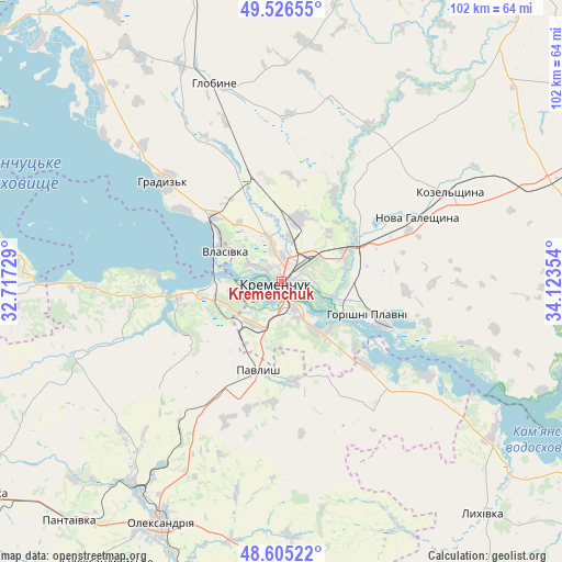
Kremenchuk GPS coordinates[2]
49° 4' 4.872" North, 33° 25' 13.476" East
| Map corner | latitude | longitude |
|---|---|---|
| Upper-left | 49.52655°, | 32.71729° |
| Center: | 49.06802°, | 33.42041° |
| Lower-right: | 48.60522°, | 34.12354° |
| Map W x H: | 102.4×102.4 km | = 63.6×63.6mi |
| max Lat: | 52.18903° ⇑32.3% North |
| Kremenchuk: | 49.06802° |
| min Lat: | ⇓67.7% South 44.39214° |
| min Long | Kremenchuk | max Long |
| 22.20555° | 33.42041° | 40.13222° |
| W 50.9%⇐ | ⇒49.1% E |
Elevation
Elevation of Kremenchuk is 66 m = 217 ft, and this is 89.8 m = 295 ft below average elevation for this country.
| Max E: |
886 m = 2907 ft | 73.5% |
| Avg. | 155.8 m = 511 ft | |
| Kremenchuk | 66 m = 217 ft | |
Min E: |
-3 m = -10 ft | 26.5% |
See also: Kremenchuk elevation on elevation.city.
Geographical zone
Kremenchuk is located in North temperate zone (between Tropic of Cancer and the Arctic Circle). Distance of this North polar circle is 1945.3 km =1208.8 mi to North.| Distance of | km | miles | from Kremenchuk |
|---|---|---|---|
| North Pole | 4551.2 | 2828 | to North |
| Arctic Circle | 1945.3 | 1208.8 | to North |
| Tropic Cancer | 2849.9 | 1770.8 | to South |
| Equator | 5455.9 | 3390.1 | to South |


Nearby cities:
15 places around Kremenchuk: (largest is in red/bold)
• Chyhyryn
55.7 km =34.6 mi,  271°
271°
• Hlobyne
37.4 km =23.2 mi,  341°
341°
• Horishni Plavni
17 km =10.6 mi,  112°
112°
• Hradyz’k
27.8 km =17.3 mi,  311°
311°
• Kamennyye Potoki
12.5 km =7.8 mi,  141°
141°
• Kobelyaky
57.2 km =35.5 mi,  80°
80°
• Kozel’shchyna
35.2 km =21.9 mi,  61°
61°
• Lutovynivka
40 km =24.9 mi, 61°
• Lykhivka
56 km =34.8 mi, 139°
• Oleksandriya
49.6 km =30.8 mi,  206°
206°
• Onufriyivka
18 km =11.2 mi,  173°
173°
• Pantayivka
58.8 km =36.5 mi,  221°
221°
• Pavlysh
17.4 km =10.8 mi,  195°
195°
• Pryyutivka
46.3 km =28.8 mi, 213°
• Svitlovods’k
13.2 km =8.2 mi,  260°
260°
In other languages:
- In France: Krementchouk
- In German: Krementschuk
- In Italian: Kremenčuk
- In Russian: Кременчуг
- In Chinese: 克列緬丘格
Sources, notices
• [Note1] Compared only with cities in Ukraine existing in our database
• [Src1] Map data: © OpenStreetMap contributors (CC-BY-SA)
• [Src2] Other city data from geonames.org with taken over terms of usage.
• [Src3] Geographical zone / Annual Mean Temperature by Robert A. Rohde @ Wikipedia
