Verenchanka geodata
Verenchanka (Chernivtsi Oblast') is a populated place; located in Ukraine in Europe/Kiev (GMT+3) time zone. With population of 3,560 people, there are 820 cities with bigger population in this country. Compared to other cities in Ukraine, 56.6% of cities are located further ↓South; 82.2% of cities are located further →East and 73.3% of cities have lower elevation than Verenchanka. Note1


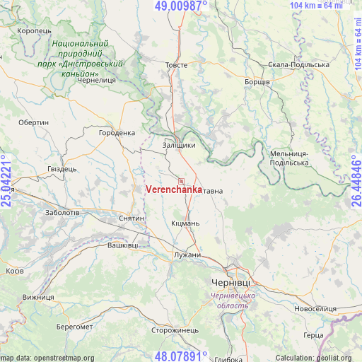
Verenchanka GPS coordinates[2]
48° 32' 47.508" North, 25° 44' 43.188" East
| Map corner | latitude | longitude |
|---|---|---|
| Upper-left | 49.00987°, | 25.04221° |
| Center: | 48.54653°, | 25.74533° |
| Lower-right: | 48.07891°, | 26.44846° |
| Map W x H: | 103.5×103.5 km | = 64.3×64.3mi |
| max Lat: | 52.18903° ⇑43.4% North |
| Verenchanka: | 48.54653° |
| min Lat: | ⇓56.6% South 44.39214° |
| min Long | Verenchanka | max Long |
| 22.20555° | 25.74533° | 40.13222° |
| W 17.8%⇐ | ⇒82.2% E |
Elevation
Elevation of Verenchanka is 218 m = 715 ft, and this is 62.2 m = 204 ft above average elevation for this country.
| Max E: |
886 m = 2907 ft | 26.7% |
| Verenchanka | 218 m 715 ft | |
| Avg. | 155.8 m = 511 ft | |
Min E: |
-3 m = -10 ft | 73.3% |
See also: Ukraine elevation on elevation.city.
Geographical zone
Verenchanka is located in North temperate zone (between Tropic of Cancer and the Arctic Circle). Distance of this North polar circle is 2003.3 km =1244.8 mi to North.| Distance of | km | miles | from Verenchanka |
|---|---|---|---|
| North Pole | 4609.2 | 2864 | to North |
| Arctic Circle | 2003.3 | 1244.8 | to North |
| Tropic Cancer | 2791.9 | 1734.8 | to South |
| Equator | 5397.9 | 3354.1 | to South |


Nearby cities:
15 places around Verenchanka: (largest is in red/bold)
• Chernivtsi
31.8 km =19.8 mi,  153°
153°
• Chernyatyn
25.2 km =15.7 mi,  300°
300°
• Horodenka
22.8 km =14.2 mi,  308°
308°
• Kadubivtsi
4.4 km =2.7 mi,  22°
22°
• Kitsman’
11.6 km =7.2 mi,  172°
172°
• Kostryzhivka
12.2 km =7.6 mi,  348°
348°
• Luzhany
20.3 km =12.6 mi, 174°
• Nyrkiv
31.7 km =19.7 mi,  340°
340°
• Shypyntsi
18.9 km =11.7 mi,  179°
179°
• Sniatyn
17.1 km =10.6 mi,  229°
229°
• Stetseva
12.7 km =7.9 mi,  260°
260°
• Tovste
33.4 km =20.8 mi,  357°
357°
• Vashkivtsi
25 km =15.5 mi,  223°
223°
• Zalishchyky
10.8 km =6.7 mi, 357°
• Zastavna
7.7 km =4.8 mi,  109°
109°
Sources, notices
• [Note1] Compared only with cities in Ukraine existing in our database
• [Src1] Map data: © OpenStreetMap contributors (CC-BY-SA)
• [Src2] Other city data from geonames.org with taken over terms of usage.
• [Src3] Geographical zone / Annual Mean Temperature by Robert A. Rohde @ Wikipedia
