Kryzhopil’ geodata
Kryzhopil’ (Vinnyts'ka) is a seat of a second-order administrative division; located in Ukraine in Europe/Kiev (GMT+3) time zone. With population of 9,024 people, there are 397 cities with bigger population in this country. Compared to other cities in Ukraine, 52.2% of cities are located further ↓South; 73% of cities are located further →East and 88.7% of cities have lower elevation than Kryzhopil’. Note1


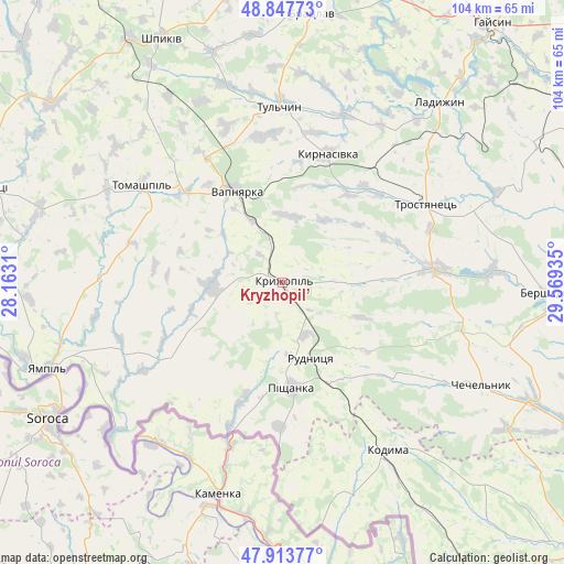
Kryzhopil’ GPS coordinates[2]
48° 22' 58.404" North, 28° 51' 58.392" East
| Map corner | latitude | longitude |
|---|---|---|
| Upper-left | 48.84773°, | 28.1631° |
| Center: | 48.38289°, | 28.86622° |
| Lower-right: | 47.91377°, | 29.56935° |
| Map W x H: | 103.8×103.8 km | = 64.5×64.5mi |
| max Lat: | 52.18903° ⇑47.8% North |
| Kryzhopil’: | 48.38289° |
| min Lat: | ⇓52.2% South 44.39214° |
| min Long | Kryzhopil’ | max Long |
| 22.20555° | 28.86622° | 40.13222° |
| W 27%⇐ | ⇒73% E |
Elevation
Elevation of Kryzhopil’ is 299 m = 981 ft, and this is 143.2 m = 470 ft above average elevation for this country.
| Max E: |
886 m = 2907 ft | 11.3% |
| Kryzhopil’ | 299 m 981 ft | |
| Avg. | 155.8 m = 511 ft | |
Min E: |
-3 m = -10 ft | 88.7% |
See also: Ukraine elevation on elevation.city.
Geographical zone
Kryzhopil’ is located in North temperate zone (between Tropic of Cancer and the Arctic Circle). Distance of this North polar circle is 2021.5 km =1256.1 mi to North.| Distance of | km | miles | from Kryzhopil’ |
|---|---|---|---|
| North Pole | 4627.4 | 2875.3 | to North |
| Arctic Circle | 2021.5 | 1256.1 | to North |
| Tropic Cancer | 2773.8 | 1723.6 | to South |
| Equator | 5379.7 | 3342.8 | to South |


Nearby cities:
15 places around Kryzhopil’: (largest is in red/bold)
• Bershad
48.1 km =29.9 mi,  91°
91°
• Chechelnyk
41.5 km =25.8 mi,  116°
116°
• Klembivka
33.6 km =20.9 mi,  271°
271°
• Kodyma
36.9 km =22.9 mi,  148°
148°
• Ladyzhyn
43.3 km =26.9 mi,  39°
39°
• Obodivka
28.3 km =17.6 mi,  84°
84°
• Pishchanka
19.6 km =12.2 mi,  175°
175°
• Tomashpil’
31.3 km =19.4 mi,  304°
304°
• Torkanivka
21.8 km =13.5 mi,  107°
107°
• Trostyanets’
30.6 km =19 mi,  62°
62°
• Tsybulevka
17.5 km =10.9 mi, 88°
• Tulchyn
32.5 km =20.2 mi,  357°
357°
• Vapnyarka
19.2 km =11.9 mi,  331°
331°
• Yampil’
45.9 km =28.5 mi,  250°
250°
• Zagnitkiv
37.2 km =23.1 mi, 177°
Sources, notices
• [Note1] Compared only with cities in Ukraine existing in our database
• [Src1] Map data: © OpenStreetMap contributors (CC-BY-SA)
• [Src2] Other city data from geonames.org with taken over terms of usage.
• [Src3] Geographical zone / Annual Mean Temperature by Robert A. Rohde @ Wikipedia
