Tsybulevka geodata
Tsybulevka (Vinnyts'ka) is a populated place; located in Ukraine in Europe/Kiev (GMT+3) time zone. With population of 1,888 people, there are 1129 cities with bigger population in this country. Compared to other cities in Ukraine, 52.4% of cities are located further ↓South; 72.2% of cities are located further →East and 68.2% of cities have lower elevation than Tsybulevka. Note1


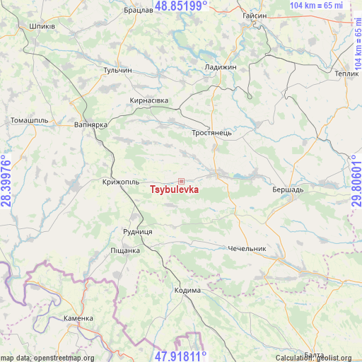
Tsybulevka GPS coordinates[2]
48° 23' 13.884" North, 29° 6' 10.368" East
| Map corner | latitude | longitude |
|---|---|---|
| Upper-left | 48.85199°, | 28.39976° |
| Center: | 48.38719°, | 29.10288° |
| Lower-right: | 47.91811°, | 29.80601° |
| Map W x H: | 103.8×103.8 km | = 64.5×64.5mi |
| max Lat: | 52.18903° ⇑47.6% North |
| Tsybulevka: | 48.38719° |
| min Lat: | ⇓52.4% South 44.39214° |
| min Long | Tsybulevka | max Long |
| 22.20555° | 29.10288° | 40.13222° |
| W 27.8%⇐ | ⇒72.2% E |
Elevation
Elevation of Tsybulevka is 199 m = 653 ft, and this is 43.2 m = 142 ft above average elevation for this country.
| Max E: |
886 m = 2907 ft | 31.8% |
| Tsybulevka | 199 m 653 ft | |
| Avg. | 155.8 m = 511 ft | |
Min E: |
-3 m = -10 ft | 68.2% |
See also: Ukraine elevation on elevation.city.
Geographical zone
Tsybulevka is located in North temperate zone (between Tropic of Cancer and the Arctic Circle). Distance of this North polar circle is 2021 km =1255.8 mi to North.| Distance of | km | miles | from Tsybulevka |
|---|---|---|---|
| North Pole | 4626.9 | 2875 | to North |
| Arctic Circle | 2021 | 1255.8 | to North |
| Tropic Cancer | 2774.2 | 1723.8 | to South |
| Equator | 5380.2 | 3343.1 | to South |


Nearby cities:
15 places around Tsybulevka: (largest is in red/bold)
• Bershad
30.7 km =19.1 mi,  94°
94°
• Bratslav
49.9 km =31 mi,  346°
346°
• Chechelnyk
27.4 km =17 mi,  134°
134°
• Kodyma
32.1 km =19.9 mi,  177°
177°
• Kryzhopil’
17.5 km =10.9 mi,  268°
268°
• Ladyzhyn
34.5 km =21.4 mi,  16°
16°
• Obodivka
10.9 km =6.8 mi,  79°
79°
• Pishchanka
25.6 km =15.9 mi,  218°
218°
• Tomashpil’
46.5 km =28.9 mi,  291°
291°
• Torkanivka
7.7 km =4.8 mi,  154°
154°
• Trostyanets’
16.7 km =10.4 mi,  35°
35°
• Tulchyn
37.1 km =23.1 mi,  329°
329°
• Vapnyarka
31.2 km =19.4 mi,  301°
301°
• Viytivka
32.8 km =20.4 mi, 82°
• Zagnitkiv
40.7 km =25.3 mi,  202°
202°
Sources, notices
• [Note1] Compared only with cities in Ukraine existing in our database
• [Src1] Map data: © OpenStreetMap contributors (CC-BY-SA)
• [Src2] Other city data from geonames.org with taken over terms of usage.
• [Src3] Geographical zone / Annual Mean Temperature by Robert A. Rohde @ Wikipedia
