Trostyanets’ geodata
Trostyanets’ (Vinnyts'ka) is a seat of a second-order administrative division; located in Ukraine in Europe/Kiev (GMT+3) time zone. In our database, there are 1661 cities with bigger population. Compared to other cities in Ukraine, 55.4% of cities are located further ↓South; 71.5% of cities are located further →East and 67.5% of cities have lower elevation than Trostyanets’. Note1


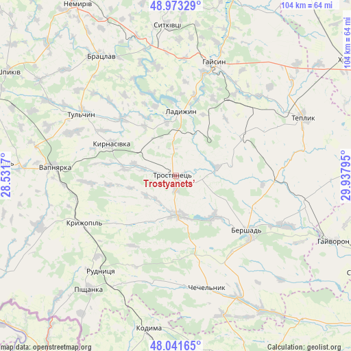
Trostyanets’ GPS coordinates[2]
48° 30' 34.596" North, 29° 14' 5.352" East
| Map corner | latitude | longitude |
|---|---|---|
| Upper-left | 48.97329°, | 28.5317° |
| Center: | 48.50961°, | 29.23482° |
| Lower-right: | 48.04165°, | 29.93795° |
| Map W x H: | 103.6×103.6 km | = 64.4×64.4mi |
| max Lat: | 52.18903° ⇑44.6% North |
| Trostyanets’: | 48.50961° |
| min Lat: | ⇓55.4% South 44.39214° |
| min Long | Trostyanets’ | max Long |
| 22.20555° | 29.23482° | 40.13222° |
| W 28.5%⇐ | ⇒71.5% E |
Elevation
Elevation of Trostyanets’ is 196 m = 643 ft, and this is 40.2 m = 132 ft above average elevation for this country.
| Max E: |
886 m = 2907 ft | 32.5% |
| Trostyanets’ | 196 m 643 ft | |
| Avg. | 155.8 m = 511 ft | |
Min E: |
-3 m = -10 ft | 67.5% |
See also: Ukraine elevation on elevation.city.
Geographical zone
Trostyanets’ is located in North temperate zone (between Tropic of Cancer and the Arctic Circle). Distance of this North polar circle is 2007.4 km =1247.3 mi to North.| Distance of | km | miles | from Trostyanets’ |
|---|---|---|---|
| North Pole | 4613.3 | 2866.6 | to North |
| Arctic Circle | 2007.4 | 1247.3 | to North |
| Tropic Cancer | 2787.8 | 1732.3 | to South |
| Equator | 5393.8 | 3351.6 | to South |


Nearby cities:
15 places around Trostyanets’: (largest is in red/bold)
• Bershad
26.1 km =16.2 mi,  127°
127°
• Bratslav
41 km =25.5 mi,  328°
328°
• Chechelnyk
34.2 km =21.3 mi,  163°
163°
• Haisyn
35.4 km =22 mi,  18°
18°
• Kodyma
46.4 km =28.8 mi,  190°
190°
• Kryzhopil’
30.6 km =19 mi,  242°
242°
• Ladyzhyn
19.5 km =12.1 mi,  0°
0°
• Obodivka
11.7 km =7.3 mi,  175°
175°
• Pishchanka
42.4 km =26.3 mi,  217°
217°
• Teplyk
41.3 km =25.7 mi,  65°
65°
• Torkanivka
21.6 km =13.4 mi,  197°
197°
• Tsybulevka
16.7 km =10.4 mi, 215°
• Tulchyn
33.9 km =21.1 mi,  302°
302°
• Vapnyarka
36.3 km =22.6 mi,  274°
274°
• Viytivka
24.5 km =15.2 mi,  112°
112°
Sources, notices
• [Note1] Compared only with cities in Ukraine existing in our database
• [Src1] Map data: © OpenStreetMap contributors (CC-BY-SA)
• [Src2] Other city data from geonames.org with taken over terms of usage.
• [Src3] Geographical zone / Annual Mean Temperature by Robert A. Rohde @ Wikipedia
