Bilokurakyne geodata
Bilokurakyne (Luhansk) is a seat of a second-order administrative division; located in Ukraine in Europe/Zaporozhye (GMT+3) time zone. With population of 7,712 people, there are 465 cities with bigger population in this country. Compared to other cities in Ukraine, 75.1% of cities are located further ↓South; 97.6% of cities are located further ←West and 65.4% of cities have higher elevation than Bilokurakyne. Note1


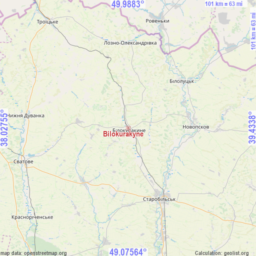
Bilokurakyne GPS coordinates[2]
49° 32' 2.76" North, 38° 43' 50.412" East
| Map corner | latitude | longitude |
|---|---|---|
| Upper-left | 49.9883°, | 38.02755° |
| Center: | 49.5341°, | 38.73067° |
| Lower-right: | 49.07564°, | 39.4338° |
| Map W x H: | 101.5×101.5 km | = 63.1×63.1mi |
| max Lat: | 52.18903° ⇑24.9% North |
| Bilokurakyne: | 49.5341° |
| min Lat: | ⇓75.1% South 44.39214° |
| min Long | Bilokurakyne | max Long |
| 22.20555° | 38.73067° | 40.13222° |
| W 97.6%⇐ | ⇒2.4% E |
Elevation
Elevation of Bilokurakyne is 88 m = 289 ft, and this is 67.8 m = 222 ft below average elevation for this country.
| Max E: |
886 m = 2907 ft | 65.4% |
| Avg. | 155.8 m = 511 ft | |
| Bilokurakyne | 88 m = 289 ft | |
Min E: |
-3 m = -10 ft | 34.6% |
See also: Ukraine elevation on elevation.city.
Geographical zone
Bilokurakyne is located in North temperate zone (between Tropic of Cancer and the Arctic Circle). Distance of this North polar circle is 1893.5 km =1176.6 mi to North.| Distance of | km | miles | from Bilokurakyne |
|---|---|---|---|
| North Pole | 4499.4 | 2795.8 | to North |
| Arctic Circle | 1893.5 | 1176.6 | to North |
| Tropic Cancer | 2901.8 | 1803.1 | to South |
| Equator | 5507.7 | 3422.3 | to South |


Nearby cities:
15 places around Bilokurakyne: (largest is in red/bold)
• Kreminna
65.5 km =40.7 mi,  214°
214°
• Lozno-Oleksandrivka
33.9 km =21.1 mi,  1°
1°
• Markivka
60.6 km =37.7 mi,  91°
91°
• Met’olkine
68.3 km =42.4 mi,  190°
190°
• Novoaydar
66.5 km =41.3 mi,  162°
162°
• Novopskov
26 km =16.2 mi, 86°
• Nyzhnya Duvanka
40.5 km =25.2 mi,  277°
277°
• Pavlivka
8.4 km =5.2 mi,  349°
349°
• Pryvillya
65.5 km =40.7 mi, 208°
• Rubizhne
63.4 km =39.4 mi,  203°
203°
• Starobil’s’k
31.3 km =19.4 mi, 155°
• Svatove
44.1 km =27.4 mi,  251°
251°
• Syevyerodonets’k
67.4 km =41.9 mi, 194°
• Troyits’ke
52.7 km =32.7 mi,  323°
323°
• Voronove
71.7 km =44.6 mi, 189°
Sources, notices
• [Note1] Compared only with cities in Ukraine existing in our database
• [Src1] Map data: © OpenStreetMap contributors (CC-BY-SA)
• [Src2] Other city data from geonames.org with taken over terms of usage.
• [Src3] Geographical zone / Annual Mean Temperature by Robert A. Rohde @ Wikipedia
