Markivka geodata
Markivka (Luhansk) is a seat of a second-order administrative division; located in Ukraine in Europe/Zaporozhye (GMT+3) time zone. With population of 7,087 people, there are 502 cities with bigger population in this country. Compared to other cities in Ukraine, 74.7% of cities are located further ↓South; 99.4% of cities are located further ←West and 56.9% of cities have higher elevation than Markivka. Note1


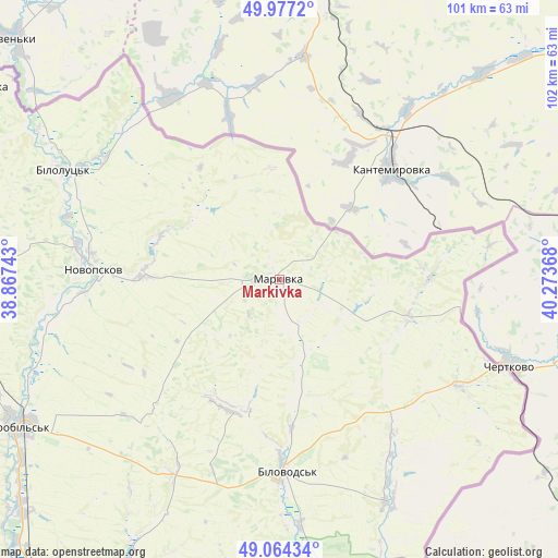
Markivka GPS coordinates[2]
49° 31' 22.44" North, 39° 34' 13.98" East
| Map corner | latitude | longitude |
|---|---|---|
| Upper-left | 49.9772°, | 38.86743° |
| Center: | 49.5229°, | 39.57055° |
| Lower-right: | 49.06434°, | 40.27368° |
| Map W x H: | 101.5×101.5 km | = 63.1×63.1mi |
| max Lat: | 52.18903° ⇑25.3% North |
| Markivka: | 49.5229° |
| min Lat: | ⇓74.7% South 44.39214° |
| min Long | Markivka | max Long |
| 22.20555° | 39.57055° | 40.13222° |
| W 99.4%⇐ | ⇒0.59999999999999% E |
Elevation
Elevation of Markivka is 115 m = 377 ft, and this is 40.8 m = 134 ft below average elevation for this country.
| Max E: |
886 m = 2907 ft | 56.9% |
| Avg. | 155.8 m = 511 ft | |
| Markivka | 115 m = 377 ft | |
Min E: |
-3 m = -10 ft | 43.1% |
See also: Ukraine elevation on elevation.city.
Geographical zone
Markivka is located in North temperate zone (between Tropic of Cancer and the Arctic Circle). Distance of this North polar circle is 1894.7 km =1177.3 mi to North.| Distance of | km | miles | from Markivka |
|---|---|---|---|
| North Pole | 4500.6 | 2796.5 | to North |
| Arctic Circle | 1894.7 | 1177.3 | to North |
| Tropic Cancer | 2900.5 | 1802.3 | to South |
| Equator | 5506.4 | 3421.5 | to South |


Nearby cities:
15 places around Markivka: (largest is in red/bold)
• Bilokurakyne
60.6 km =37.7 mi,  271°
271°
• Bilovods'k
35 km =21.7 mi,  177°
177°
• Lozno-Oleksandrivka
69.3 km =43.1 mi,  300°
300°
• Met’olkine
99 km =61.5 mi,  228°
228°
• Milove
43.8 km =27.2 mi,  112°
112°
• Novoaydar
74.5 km =46.3 mi,  213°
213°
• Novopskov
34.8 km =21.6 mi, 274°
• Nyzhnya Duvanka
100.9 km =62.7 mi, 273°
• Pavlivka
62.8 km =39 mi,  278°
278°
• Shchastya
90.5 km =56.2 mi,  195°
195°
• Stanytsya Luhans’ka
96.8 km =60.1 mi, 183°
• Starobil’s’k
54.9 km =34.1 mi,  240°
240°
• Syevyerodonets’k
101.1 km =62.8 mi, 230°
• Tr’okhizbenka
95.9 km =59.6 mi, 207°
• Voronove
100.4 km =62.4 mi, 226°
Sources, notices
• [Note1] Compared only with cities in Ukraine existing in our database
• [Src1] Map data: © OpenStreetMap contributors (CC-BY-SA)
• [Src2] Other city data from geonames.org with taken over terms of usage.
• [Src3] Geographical zone / Annual Mean Temperature by Robert A. Rohde @ Wikipedia
