Muhororo geodata
Muhororo (Western Region) is a populated place; located in Uganda in Africa/Kampala (GMT+3) time zone. With population of 1,567 people, there are 78 cities with bigger population in this country. Compared to other cities in Uganda, 56.8% of cities are located further ↓South; 81.5% of cities are located further →East and 51.4% of cities have lower elevation than Muhororo. Note1
Administrative division(s):
- Level 1: Western Region
- Level 2: Kagadi
- Level 3: Buyaga County
- Level 4: Muhoro Town Council


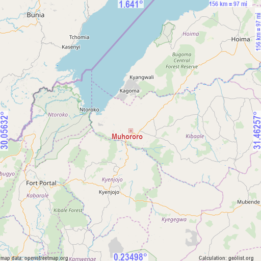
Muhororo GPS coordinates[2]
0° 56' 17.016" North, 30° 45' 33.984" East
| Map corner | latitude | longitude |
|---|---|---|
| Upper-left | 1.641°, | 30.05632° |
| Center: | 0.93806°, | 30.75944° |
| Lower-right: | 0.23498°, | 31.46257° |
| Map W x H: | 156.3×156.3 km | = 97.1×97.1mi |
| max Lat: | 3.66088° ⇑43.2% North |
| Muhororo: | 0.93806° |
| min Lat: | ⇓56.8% South -1.28538° |
| min Long | Muhororo | max Long |
| 29.65° | 30.75944° | 34.95° |
| W 18.5%⇐ | ⇒81.5% E |
Elevation
Elevation of Muhororo is 1191 m = 3907 ft, and this is 68 m = 223 ft below average elevation for this country.
| Max E: |
4129 m = 13547 ft | 48.6% |
| Avg. | 1259 m = 4131 ft | |
| Muhororo | 1191 m = 3907 ft | |
Min E: |
622 m = 2041 ft | 51.4% |
See also: Uganda elevation on elevation.city.
Geographical zone
Muhororo is located in North Torrid zone (between Equator and Tropic of Cancer). Distance of Equator is 104.3 km =64.8 mi to South.| Distance of | km | miles | from Muhororo |
|---|---|---|---|
| North Pole | 9902.8 | 6153.3 | to North |
| Arctic Circle | 7296.9 | 4534.1 | to North |
| Tropic Cancer | 2501.6 | 1554.4 | to North |
| Equator | 104.3 | 64.8 | to South |


Nearby cities:
15 places around Muhororo: (largest is in red/bold)
• Bundibugyo
81.3 km =50.5 mi,  251°
251°
• Fort Portal
62 km =38.5 mi,  240°
240°
• Hoima
85.9 km =53.4 mi,  50°
50°
• Kagadi
5.5 km =3.4 mi,  90°
90°
• Kakumiro
65.1 km =40.5 mi,  105°
105°
• Kamwenge
90.2 km =56 mi,  202°
202°
• Kasese
112.7 km =70 mi,  221°
221°
• Kibale
37.4 km =23.2 mi, 114°
• Kibiito
81.2 km =50.5 mi,  230°
230°
• Kigorobya
97 km =60.3 mi,  39°
39°
• Kyegegwa
57.7 km =35.9 mi,  147°
147°
• Kyenjojo
37.3 km =23.2 mi, 204°
• Margherita
112.5 km =69.9 mi, 239°
• Mubende
82.3 km =51.1 mi,  120°
120°
• Ntoroko
33 km =20.5 mi,  290°
290°
Sources, notices
• [Note1] Compared only with cities in Uganda existing in our database
• [Src1] Map data: © OpenStreetMap contributors (CC-BY-SA)
• [Src2] Other city data from geonames.org with taken over terms of usage.
• [Src3] Geographical zone / Annual Mean Temperature by Robert A. Rohde @ Wikipedia
