Fort Portal geodata
Fort Portal (Western Region) is a seat of a second-order administrative division; located in Uganda in Africa/Kampala (GMT+3) time zone. With population of 42,670 people, there are 18 cities with bigger population in this country. Compared to other cities in Uganda, 55.5% of cities are located further ↑North; 89% of cities are located further →East and 88.4% of cities have lower elevation than Fort Portal. Note1
Administrative division(s):
- Level 1: Western Region
- Level 2: Kabarole District
- Level 3: Fort Portal Municipality
- Level 4: Western Division


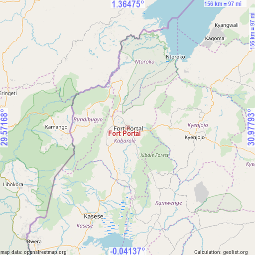
Fort Portal GPS coordinates[2]
0° 39' 42.264" North, 30° 16' 29.28" East
| Map corner | latitude | longitude |
|---|---|---|
| Upper-left | 1.36475°, | 29.57168° |
| Center: | 0.66174°, | 30.2748° |
| Lower-right: | -0.04137°, | 30.97793° |
| Map W x H: | 156.3×156.3 km | = 97.1×97.1mi |
| max Lat: | 3.66088° ⇑55.5% North |
| Fort Portal: | 0.66174° |
| min Lat: | ⇓44.5% South -1.28538° |
| min Long | Fort Portal | max Long |
| 29.65° | 30.2748° | 34.95° |
| W 11%⇐ | ⇒89% E |
Elevation
Elevation of Fort Portal is 1518 m = 4980 ft, and this is 259 m = 850 ft above average elevation for this country.
| Max E: |
4129 m = 13547 ft | 11.6% |
| Fort Portal | 1518 m 4980 ft | |
| Avg. | 1259 m = 4131 ft | |
Min E: |
622 m = 2041 ft | 88.4% |
See also: Fort Portal elevation on elevation.city.
Geographical zone
Fort Portal is located in North Torrid zone (between Equator and Tropic of Cancer). Distance of Equator is 73.6 km =45.7 mi to South.| Distance of | km | miles | from Fort Portal |
|---|---|---|---|
| North Pole | 9933.5 | 6172.4 | to North |
| Arctic Circle | 7327.6 | 4553.2 | to North |
| Tropic Cancer | 2532.3 | 1573.5 | to North |
| Equator | 73.6 | 45.7 | to South |


Nearby cities:
15 places around Fort Portal: (largest is in red/bold)
• Buhweju
112.6 km =70 mi,  178°
178°
• Bundibugyo
24 km =14.9 mi,  283°
283°
• Ibanda
91.8 km =57 mi,  164°
164°
• Kagadi
66.8 km =41.5 mi,  62°
62°
• Kamwenge
56.5 km =35.1 mi, 159°
• Kasese
57.3 km =35.6 mi,  201°
201°
• Kibale
89.4 km =55.6 mi,  80°
80°
• Kibiito
22.5 km =14 mi, 204°
• Kilembe
59.2 km =36.8 mi,  209°
209°
• Kyegegwa
87.1 km =54.1 mi,  101°
101°
• Kyenjojo
38.7 km =24 mi,  94°
94°
• Margherita
50.5 km =31.4 mi,  237°
237°
• Muhororo
62 km =38.5 mi, 60°
• Ntoroko
48 km =29.8 mi,  28°
28°
• Rubirizi
108 km =67.1 mi,  188°
188°
Sources, notices
• [Note1] Compared only with cities in Uganda existing in our database
• [Src1] Map data: © OpenStreetMap contributors (CC-BY-SA)
• [Src2] Other city data from geonames.org with taken over terms of usage.
• [Src3] Geographical zone / Annual Mean Temperature by Robert A. Rohde @ Wikipedia
