Bundibugyo geodata
Bundibugyo (Western Region) is a seat of a second-order administrative division; located in Uganda in Africa/Kampala (GMT+3) time zone. With population of 16,919 people, there are 43 cities with bigger population in this country. Compared to other cities in Uganda, 52.1% of cities are located further ↑North; 93.8% of cities are located further →East and 97.9% of cities have higher elevation than Bundibugyo. Note1
Administrative division(s):
- Level 1: Western Region
- Level 2: Bundibugyo District
- Level 3: Bwamba County
- Level 4: Bundibugyo Town Council


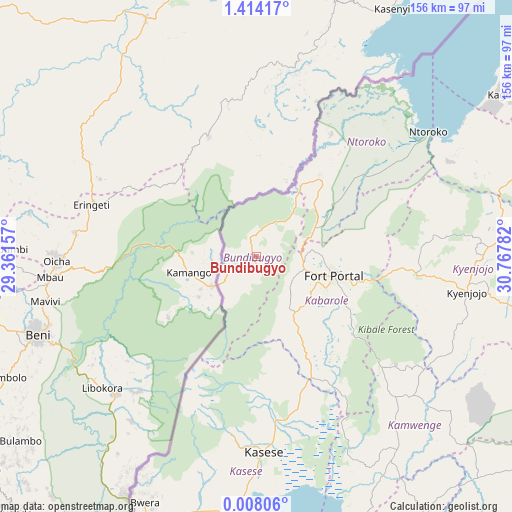
Bundibugyo GPS coordinates[2]
0° 42' 40.212" North, 30° 3' 52.884" East
| Map corner | latitude | longitude |
|---|---|---|
| Upper-left | 1.41417°, | 29.36157° |
| Center: | 0.71117°, | 30.06469° |
| Lower-right: | 0.00806°, | 30.76782° |
| Map W x H: | 156.3×156.3 km | = 97.1×97.1mi |
| max Lat: | 3.66088° ⇑52.1% North |
| Bundibugyo: | 0.71117° |
| min Lat: | ⇓47.9% South -1.28538° |
| min Long | Bundibugyo | max Long |
| 29.65° | 30.06469° | 34.95° |
| W 6.2%⇐ | ⇒93.8% E |
Elevation
Elevation of Bundibugyo is 930 m = 3051 ft, and this is 329 m = 1079 ft below average elevation for this country.
| Max E: |
4129 m = 13547 ft | 97.9% |
| Avg. | 1259 m = 4131 ft | |
| Bundibugyo | 930 m = 3051 ft | |
Min E: |
622 m = 2041 ft | 2.1% |
See also: Uganda elevation on elevation.city.
Geographical zone
Bundibugyo is located in North Torrid zone (between Equator and Tropic of Cancer). Distance of Equator is 79.1 km =49.2 mi to South.| Distance of | km | miles | from Bundibugyo |
|---|---|---|---|
| North Pole | 9928 | 6169 | to North |
| Arctic Circle | 7322.1 | 4549.7 | to North |
| Tropic Cancer | 2526.8 | 1570.1 | to North |
| Equator | 79.1 | 49.2 | to South |


Nearby cities:
15 places around Bundibugyo: (largest is in red/bold)
• Buhweju
120.9 km =75.1 mi,  167°
167°
• Fort Portal
24 km =14.9 mi,  103°
103°
• Ibanda
105.5 km =65.6 mi,  152°
152°
• Kagadi
86.5 km =53.7 mi,  73°
73°
• Kamwenge
72.6 km =45.1 mi,  143°
143°
• Kasese
58.7 km =36.5 mi,  177°
177°
• Kibale
111.8 km =69.5 mi,  84°
84°
• Kibiito
29.6 km =18.4 mi, 151°
• Kilembe
57.3 km =35.6 mi,  185°
185°
• Kyegegwa
111.1 km =69 mi, 102°
• Kyenjojo
62.5 km =38.8 mi, 98°
• Margherita
37.8 km =23.5 mi,  210°
210°
• Muhororo
81.3 km =50.5 mi, 71°
• Ntoroko
59.1 km =36.7 mi,  51°
51°
• Rubirizi
112.6 km =70 mi, 176°
Sources, notices
• [Note1] Compared only with cities in Uganda existing in our database
• [Src1] Map data: © OpenStreetMap contributors (CC-BY-SA)
• [Src2] Other city data from geonames.org with taken over terms of usage.
• [Src3] Geographical zone / Annual Mean Temperature by Robert A. Rohde @ Wikipedia
