Margherita geodata
Margherita (Western Region) is a populated place; located in Uganda in Africa/Kampala (GMT+3) time zone. With population of 5,109 people, there are 74 cities with bigger population in this country. Compared to other cities in Uganda, 65.1% of cities are located further ↑North; 96.6% of cities are located further →East and 100% of cities have lower elevation than Margherita. Note1


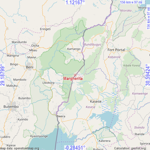
Margherita GPS coordinates[2]
0° 25' 6.996" North, 29° 53' 27.996" East
| Map corner | latitude | longitude |
|---|---|---|
| Upper-left | 1.12167°, | 29.18799° |
| Center: | 0.41861°, | 29.89111° |
| Lower-right: | -0.28451°, | 30.59424° |
| Map W x H: | 156.4×156.4 km | = 97.2×97.2mi |
| max Lat: | 3.66088° ⇑65.1% North |
| Margherita: | 0.41861° |
| min Lat: | ⇓34.9% South -1.28538° |
| min Long | Margherita | max Long |
| 29.65° | 29.89111° | 34.95° |
| W 3.4%⇐ | ⇒96.6% E |
Elevation
Elevation of Margherita is 4129 m = 13547 ft, and this is 2870 m = 9416 ft above average elevation for this country.
| Max E: |
4129 m = 13547 ft | 0% |
| Margherita | 4129 m 13547 ft | |
| Avg. | 1259 m = 4131 ft | |
Min E: |
622 m = 2041 ft | 100% |
See also: Uganda elevation on elevation.city.
Geographical zone
Margherita is located in North Torrid zone (between Equator and Tropic of Cancer). Distance of Equator is 46.5 km =28.9 mi to South.| Distance of | km | miles | from Margherita |
|---|---|---|---|
| North Pole | 9960.5 | 6189.2 | to North |
| Arctic Circle | 7354.6 | 4569.9 | to North |
| Tropic Cancer | 2559.4 | 1590.3 | to North |
| Equator | 46.5 | 28.9 | to South |


Nearby cities:
15 places around Margherita: (largest is in red/bold)
• Buhweju
96.8 km =60.1 mi,  151°
151°
• Bundibugyo
37.8 km =23.5 mi,  30°
30°
• Bushenyi
111.2 km =69.1 mi,  162°
162°
• Fort Portal
50.5 km =31.4 mi,  57°
57°
• Ibanda
91.1 km =56.6 mi,  132°
132°
• Kamwenge
67.7 km =42.1 mi,  112°
112°
• Kasese
33.8 km =21 mi,  140°
140°
• Kibiito
34.1 km =21.2 mi,  78°
78°
• Kihihi
112 km =69.6 mi,  191°
191°
• Kilembe
28 km =17.4 mi, 151°
• Kyenjojo
84.6 km =52.6 mi,  73°
73°
• Muhororo
112.5 km =69.9 mi, 59°
• Nsika
105.2 km =65.4 mi, 145°
• Ntoroko
95.4 km =59.3 mi,  43°
43°
• Rubirizi
84.2 km =52.3 mi, 161°
Sources, notices
• [Note1] Compared only with cities in Uganda existing in our database
• [Src1] Map data: © OpenStreetMap contributors (CC-BY-SA)
• [Src2] Other city data from geonames.org with taken over terms of usage.
• [Src3] Geographical zone / Annual Mean Temperature by Robert A. Rohde @ Wikipedia
