Kyenjojo geodata
Kyenjojo (Western Region) is a seat of a second-order administrative division; located in Uganda in Africa/Kampala (GMT+3) time zone. With population of 18,600 people, there are 40 cities with bigger population in this country. Compared to other cities in Uganda, 56.8% of cities are located further ↑North; 83.6% of cities are located further →East and 76% of cities have lower elevation than Kyenjojo. Note1
Administrative division(s):
- Level 1: Western Region
- Level 2: Kyenjojo District
- Level 3: Mwenge County
- Level 4: Nyantungo


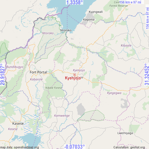
Kyenjojo GPS coordinates[2]
0° 37' 58.008" North, 30° 37' 17.004" East
| Map corner | latitude | longitude |
|---|---|---|
| Upper-left | 1.3358°, | 29.91827° |
| Center: | 0.63278°, | 30.62139° |
| Lower-right: | -0.07033°, | 31.32452° |
| Map W x H: | 156.3×156.4 km | = 97.1×97.2mi |
| max Lat: | 3.66088° ⇑56.8% North |
| Kyenjojo: | 0.63278° |
| min Lat: | ⇓43.2% South -1.28538° |
| min Long | Kyenjojo | max Long |
| 29.65° | 30.62139° | 34.95° |
| W 16.4%⇐ | ⇒83.6% E |
Elevation
Elevation of Kyenjojo is 1334 m = 4377 ft, and this is 75 m = 246 ft above average elevation for this country.
| Max E: |
4129 m = 13547 ft | 24% |
| Kyenjojo | 1334 m 4377 ft | |
| Avg. | 1259 m = 4131 ft | |
Min E: |
622 m = 2041 ft | 76% |
See also: Uganda elevation on elevation.city.
Geographical zone
Kyenjojo is located in North Torrid zone (between Equator and Tropic of Cancer). Distance of Equator is 70.4 km =43.7 mi to South.| Distance of | km | miles | from Kyenjojo |
|---|---|---|---|
| North Pole | 9936.7 | 6174.4 | to North |
| Arctic Circle | 7330.8 | 4555.1 | to North |
| Tropic Cancer | 2535.6 | 1575.5 | to North |
| Equator | 70.4 | 43.7 | to South |


Nearby cities:
15 places around Kyenjojo: (largest is in red/bold)
• Bundibugyo
62.5 km =38.8 mi,  278°
278°
• Fort Portal
38.7 km =24 mi,  274°
274°
• Ibanda
86.4 km =53.7 mi,  189°
189°
• Kagadi
39.8 km =24.7 mi,  31°
31°
• Kakumiro
79.8 km =49.6 mi,  78°
78°
• Kamwenge
53 km =32.9 mi,  200°
200°
• Kasese
78 km =48.5 mi,  230°
230°
• Kibale
52.9 km =32.9 mi,  69°
69°
• Kibiito
50.7 km =31.5 mi,  250°
250°
• Kilembe
83.1 km =51.6 mi, 234°
• Kyegegwa
48.9 km =30.4 mi,  107°
107°
• Margherita
84.6 km =52.6 mi, 253°
• Mubende
86.4 km =53.7 mi,  95°
95°
• Muhororo
37.3 km =23.2 mi,  24°
24°
• Ntoroko
48 km =29.8 mi,  341°
341°
Sources, notices
• [Note1] Compared only with cities in Uganda existing in our database
• [Src1] Map data: © OpenStreetMap contributors (CC-BY-SA)
• [Src2] Other city data from geonames.org with taken over terms of usage.
• [Src3] Geographical zone / Annual Mean Temperature by Robert A. Rohde @ Wikipedia
