Ntoroko geodata
Ntoroko (Western Region) is a seat of a second-order administrative division; located in Uganda in Africa/Kampala (GMT+3) time zone. In our database, there are 80 cities with bigger population. Compared to other cities in Uganda, 60.3% of cities are located further ↓South; 84.9% of cities are located further →East and 100% of cities have higher elevation than Ntoroko. Note1
Administrative division(s):
- Level 1: Western Region
- Level 2: Ntoroko District
- Level 3: Ntoroko
- Level 4: Rwebisengo


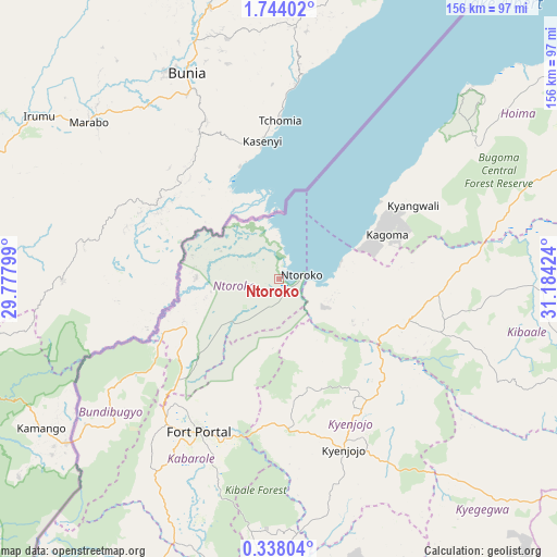
Ntoroko GPS coordinates[2]
1° 2' 27.996" North, 30° 28' 51.996" East
| Map corner | latitude | longitude |
|---|---|---|
| Upper-left | 1.74402°, | 29.77799° |
| Center: | 1.04111°, | 30.48111° |
| Lower-right: | 0.33804°, | 31.18424° |
| Map W x H: | 156.3×156.3 km | = 97.1×97.1mi |
| max Lat: | 3.66088° ⇑39.7% North |
| Ntoroko: | 1.04111° |
| min Lat: | ⇓60.3% South -1.28538° |
| min Long | Ntoroko | max Long |
| 29.65° | 30.48111° | 34.95° |
| W 15.1%⇐ | ⇒84.9% E |
Elevation
Elevation of Ntoroko is 622 m = 2041 ft, and this is 637 m = 2090 ft below average elevation for this country.
| Max E: |
4129 m = 13547 ft | 100% |
| Avg. | 1259 m = 4131 ft | |
| Ntoroko | 622 m = 2041 ft | |
Min E: |
622 m = 2041 ft | 0% |
See also: Uganda elevation on elevation.city.
Geographical zone
Ntoroko is located in North Torrid zone (between Equator and Tropic of Cancer). Distance of Equator is 115.8 km =72 mi to South.| Distance of | km | miles | from Ntoroko |
|---|---|---|---|
| North Pole | 9891.3 | 6146.2 | to North |
| Arctic Circle | 7285.4 | 4526.9 | to North |
| Tropic Cancer | 2490.2 | 1547.3 | to North |
| Equator | 115.8 | 72 | to South |


Nearby cities:
15 places around Ntoroko: (largest is in red/bold)
• Bundibugyo
59.1 km =36.7 mi,  231°
231°
• Fort Portal
48 km =29.8 mi,  208°
208°
• Hoima
106.2 km =66 mi,  65°
65°
• Kagadi
38.2 km =23.7 mi,  107°
107°
• Kakumiro
98 km =60.9 mi, 107°
• Kamwenge
95.1 km =59.1 mi,  181°
181°
• Kasese
105.1 km =65.3 mi,  204°
204°
• Kibale
70.4 km =43.7 mi, 112°
• Kibiito
70.4 km =43.7 mi, 207°
• Kigorobya
112.1 km =69.7 mi,  55°
55°
• Kilembe
107.2 km =66.6 mi, 209°
• Kyegegwa
86.4 km =53.7 mi,  133°
133°
• Kyenjojo
48 km =29.8 mi,  161°
161°
• Margherita
95.4 km =59.3 mi,  223°
223°
• Muhororo
33 km =20.5 mi, 110°
Sources, notices
• [Note1] Compared only with cities in Uganda existing in our database
• [Src1] Map data: © OpenStreetMap contributors (CC-BY-SA)
• [Src2] Other city data from geonames.org with taken over terms of usage.
• [Src3] Geographical zone / Annual Mean Temperature by Robert A. Rohde @ Wikipedia
