Kilembe geodata
Kilembe (Western Region) is a populated place; located in Uganda in Africa/Kampala (GMT+3) time zone. With population of 7,914 people, there are 67 cities with bigger population in this country. Compared to other cities in Uganda, 76% of cities are located further ↑North; 94.5% of cities are located further →East and 71.9% of cities have lower elevation than Kilembe. Note1
Administrative division(s):
- Level 1: Western Region
- Level 2: Kasese District
- Level 3: Kasese Municipality
- Level 4: Bulembia Division


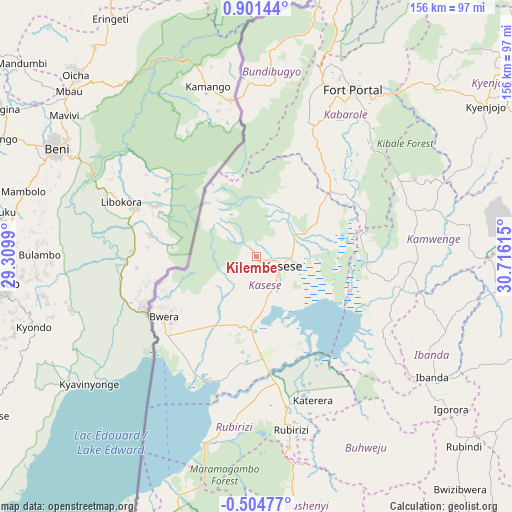
Kilembe GPS coordinates[2]
0° 11' 54.06" North, 30° 0' 46.872" East
| Map corner | latitude | longitude |
|---|---|---|
| Upper-left | 0.90144°, | 29.3099° |
| Center: | 0.19835°, | 30.01302° |
| Lower-right: | -0.50477°, | 30.71615° |
| Map W x H: | 156.4×156.4 km | = 97.2×97.2mi |
| max Lat: | 3.66088° ⇑76% North |
| Kilembe: | 0.19835° |
| min Lat: | ⇓24% South -1.28538° |
| min Long | Kilembe | max Long |
| 29.65° | 30.01302° | 34.95° |
| W 5.5%⇐ | ⇒94.5% E |
Elevation
Elevation of Kilembe is 1295 m = 4249 ft, and this is 36 m = 118 ft above average elevation for this country.
| Max E: |
4129 m = 13547 ft | 28.1% |
| Kilembe | 1295 m 4249 ft | |
| Avg. | 1259 m = 4131 ft | |
Min E: |
622 m = 2041 ft | 71.9% |
See also: Uganda elevation on elevation.city.
Geographical zone
Kilembe is located in North Torrid zone (between Equator and Tropic of Cancer). Distance of Equator is 22.1 km =13.7 mi to South.| Distance of | km | miles | from Kilembe |
|---|---|---|---|
| North Pole | 9985 | 6204.4 | to North |
| Arctic Circle | 7379.1 | 4585.2 | to North |
| Tropic Cancer | 2583.9 | 1605.6 | to North |
| Equator | 22.1 | 13.7 | to South |


Nearby cities:
15 places around Kilembe: (largest is in red/bold)
• Buhweju
68.9 km =42.8 mi,  152°
152°
• Bundibugyo
57.3 km =35.6 mi,  5°
5°
• Bushenyi
84 km =52.2 mi,  166°
166°
• Fort Portal
59.2 km =36.8 mi,  29°
29°
• Ibanda
65.2 km =40.5 mi,  124°
124°
• Kamwenge
49 km =30.4 mi,  91°
91°
• Kasese
8 km =5 mi,  102°
102°
• Kibiito
36.9 km =22.9 mi, 32°
• Kihihi
92.4 km =57.4 mi,  202°
202°
• Kiruhura
102.3 km =63.6 mi, 115°
• Kyenjojo
83.1 km =51.6 mi,  54°
54°
• Margherita
28 km =17.4 mi,  331°
331°
• Mitoma
98.3 km =61.1 mi,  176°
176°
• Nsika
77.4 km =48.1 mi,  143°
143°
• Rubirizi
56.9 km =35.4 mi, 166°
Sources, notices
• [Note1] Compared only with cities in Uganda existing in our database
• [Src1] Map data: © OpenStreetMap contributors (CC-BY-SA)
• [Src2] Other city data from geonames.org with taken over terms of usage.
• [Src3] Geographical zone / Annual Mean Temperature by Robert A. Rohde @ Wikipedia
