Ely geodata
Ely (Nevada) is a seat of a second-order administrative division; located in United States in America/Los_Angeles (GMT-7) time zone. With population of 4,134 people, there are 8061 cities with bigger population in this country. Compared to other cities in United States, 52.6% of cities are located further ↑North; 88.9% of cities are located further →East and 99% of cities have lower elevation than Ely. Note1


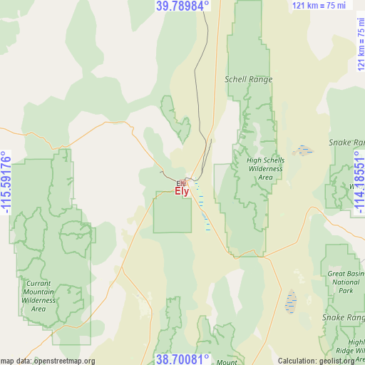
Ely GPS coordinates[2]
39° 14' 50.784" North, 114° 53' 19.068" West
| Map corner | latitude | longitude |
|---|---|---|
| Upper-left | 39.78984°, | -115.59176° |
| Center: | 39.24744°, | -114.88863° |
| Lower-right: | 38.70081°, | -114.18551° |
| Map W x H: | 121.1×121.1 km | = 75.2×75.2mi |
| max Lat: | 71.29058° ⇑52.6% North |
| Ely: | 39.24744° |
| min Lat: | ⇓47.4% South 19.06759° |
| min Long | Ely | max Long |
| -171.73463° | -114.88863° | -66.98998° |
| W 11.1%⇐ | ⇒88.9% E |
Elevation
Elevation of Ely is 1968 m = 6457 ft, and this is 1673.2 m = 5490 ft above average elevation for this country.
| Max E: |
3189 m = 10463 ft | 1% |
| Ely | 1968 m 6457 ft | |
| Avg. | 294.8 m = 967 ft | |
Min E: |
-60 m = -197 ft | 99% |
See also: United States elevation on elevation.city.
Geographical zone
Ely is located in North temperate zone (between Tropic of Cancer and the Arctic Circle). Distance of this Northern Tropic circle is 1758 km =1092.4 mi to South.| Distance of | km | miles | from Ely |
|---|---|---|---|
| North Pole | 5643.2 | 3506.5 | to North |
| Arctic Circle | 3037.3 | 1887.3 | to North |
| Tropic Cancer | 1758 | 1092.4 | to South |
| Equator | 4363.9 | 2711.6 | to South |


Nearby cities:
15 places around Ely: (largest is in red/bold)
• Caliente
184.5 km =114.6 mi,  169°
169°
• Carlin
193.1 km =120 mi,  327°
327°
• Delta
199.2 km =123.8 mi,  86°
86°
• Elko
191.3 km =118.9 mi,  337°
337°
• Eureka
96.7 km =60.1 mi,  287°
287°
• Hinckley
191 km =118.7 mi, 87°
• McGill
19.9 km =12.4 mi,  28°
28°
• Milford
188.2 km =116.9 mi,  120°
120°
• Minersville
205.5 km =127.7 mi, 123°
• Osino
198.5 km =123.3 mi, 340°
• Panaca
167.7 km =104.2 mi,  164°
164°
• Pioche
151.3 km =94 mi, 165°
• Spring Creek
174.9 km =108.7 mi, 340°
• Wendover
180.8 km =112.3 mi,  23°
23°
• West Wendover
179.8 km =111.7 mi, 22°
Sources, notices
• [Note1] Compared only with cities in United States existing in our database
• [Src1] Map data: © OpenStreetMap contributors (CC-BY-SA)
• [Src2] Other city data from geonames.org with taken over terms of usage.
• [Src3] Geographical zone / Annual Mean Temperature by Robert A. Rohde @ Wikipedia
