McGill geodata
McGill (Nevada) is a populated place; located in United States in America/Los_Angeles (GMT-7) time zone. With population of 1,148 people, there are 15391 cities with bigger population in this country. Compared to other cities in United States, 51.5% of cities are located further ↑North; 88.9% of cities are located further →East and 98.8% of cities have lower elevation than McGill. Note1


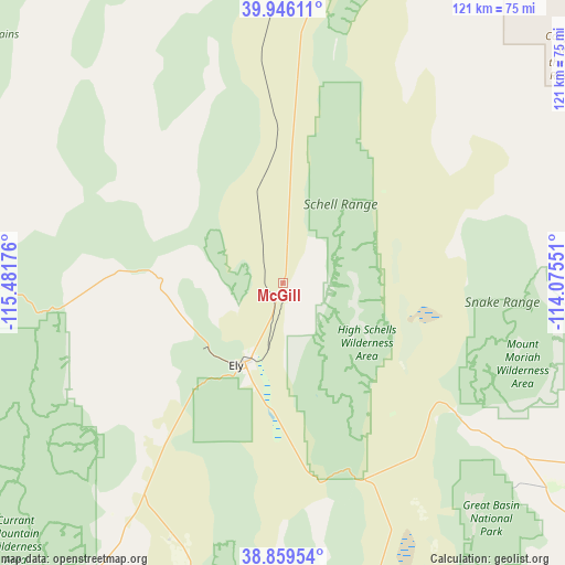
McGill GPS coordinates[2]
39° 24' 17.784" North, 114° 46' 43.068" West
| Map corner | latitude | longitude |
|---|---|---|
| Upper-left | 39.94611°, | -115.48176° |
| Center: | 39.40494°, | -114.77863° |
| Lower-right: | 38.85954°, | -114.07551° |
| Map W x H: | 120.8×120.8 km | = 75.1×75.1mi |
| max Lat: | 71.29058° ⇑51.5% North |
| McGill: | 39.40494° |
| min Lat: | ⇓48.5% South 19.06759° |
| min Long | McGill | max Long |
| -171.73463° | -114.77863° | -66.98998° |
| W 11.1%⇐ | ⇒88.9% E |
Elevation
Elevation of McGill is 1899 m = 6230 ft, and this is 1604.2 m = 5263 ft above average elevation for this country.
| Max E: |
3189 m = 10463 ft | 1.2% |
| McGill | 1899 m 6230 ft | |
| Avg. | 294.8 m = 967 ft | |
Min E: |
-60 m = -197 ft | 98.8% |
See also: United States elevation on elevation.city.
Geographical zone
McGill is located in North temperate zone (between Tropic of Cancer and the Arctic Circle). Distance of this Northern Tropic circle is 1775.5 km =1103.2 mi to South.| Distance of | km | miles | from McGill |
|---|---|---|---|
| North Pole | 5625.6 | 3495.6 | to North |
| Arctic Circle | 3019.8 | 1876.4 | to North |
| Tropic Cancer | 1775.5 | 1103.2 | to South |
| Equator | 4381.4 | 2722.5 | to South |


Nearby cities:
15 places around McGill: (largest is in red/bold)
• Carlin
184.1 km =114.4 mi,  322°
322°
• Delta
189.3 km =117.6 mi,  91°
91°
• Dugway
196 km =121.8 mi,  62°
62°
• Elko
179.4 km =111.5 mi,  332°
332°
• Ely
19.9 km =12.4 mi,  208°
208°
• Eureka
102.2 km =63.5 mi,  276°
276°
• Hinckley
181.4 km =112.7 mi, 92°
• Milford
189.6 km =117.8 mi,  126°
126°
• Osino
185.6 km =115.3 mi,  336°
336°
• Panaca
182.7 km =113.5 mi,  169°
169°
• Pioche
166.5 km =103.5 mi, 170°
• Spring Creek
162.2 km =100.8 mi, 334°
• Wells
190.4 km =118.3 mi,  355°
355°
• Wendover
161 km =100 mi,  23°
23°
• West Wendover
160 km =99.4 mi, 22°
Sources, notices
• [Note1] Compared only with cities in United States existing in our database
• [Src1] Map data: © OpenStreetMap contributors (CC-BY-SA)
• [Src2] Other city data from geonames.org with taken over terms of usage.
• [Src3] Geographical zone / Annual Mean Temperature by Robert A. Rohde @ Wikipedia
