New Town geodata
New Town (North Dakota) is a populated place; located in United States in America/Chicago (GMT-5) time zone. With population of 2,521 people, there are 10564 cities with bigger population in this country. Compared to other cities in United States, 98.6% of cities are located further ↓South; 82.1% of cities are located further →East and 89.4% of cities have lower elevation than New Town. Note1
Administrative division(s):
- Level 1: North Dakota
- Level 2: Mountrail County
- Level 3: City of New Town


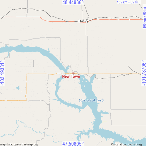
New Town GPS coordinates[2]
47° 58' 51.06" North, 102° 29' 24.648" West
| Map corner | latitude | longitude |
|---|---|---|
| Upper-left | 48.44936°, | -103.19331° |
| Center: | 47.98085°, | -102.49018° |
| Lower-right: | 47.50805°, | -101.78706° |
| Map W x H: | 104.7×104.7 km | = 65.1×65.1mi |
| max Lat: | 71.29058° ⇑1.4% North |
| New Town: | 47.98085° |
| min Lat: | ⇓98.6% South 19.06759° |
| min Long | New Town | max Long |
| -171.73463° | -102.49018° | -66.98998° |
| W 17.9%⇐ | ⇒82.1% E |
Elevation
Elevation of New Town is 583 m = 1913 ft, and this is 288.2 m = 946 ft above average elevation for this country.
| Max E: |
3189 m = 10463 ft | 10.6% |
| New Town | 583 m 1913 ft | |
| Avg. | 294.8 m = 967 ft | |
Min E: |
-60 m = -197 ft | 89.4% |
See also: United States elevation on elevation.city.
Geographical zone
New Town is located in North temperate zone (between Tropic of Cancer and the Arctic Circle). Distance of this North polar circle is 2066.2 km =1283.9 mi to North.| Distance of | km | miles | from New Town |
|---|---|---|---|
| North Pole | 4672.1 | 2903.1 | to North |
| Arctic Circle | 2066.2 | 1283.9 | to North |
| Tropic Cancer | 2729.1 | 1695.8 | to South |
| Equator | 5335 | 3315 | to South |


Nearby cities:
15 places around New Town: (largest is in red/bold)
• Berthold
67 km =41.6 mi,  56°
56°
• Burlington
85.3 km =53 mi,  67°
67°
• Four Bears Village
6.6 km =4.1 mi,  271°
271°
• Garrison
88.2 km =54.8 mi,  114°
114°
• Kenmare
82.8 km =51.4 mi,  21°
21°
• Killdeer
70.5 km =43.8 mi,  196°
196°
• Mandaree
31.2 km =19.4 mi,  206°
206°
• Manning
86.1 km =53.5 mi,  194°
194°
• Minot
93 km =57.8 mi, 72°
• Parshall
26.6 km =16.5 mi,  96°
96°
• Ray
64.3 km =40 mi,  308°
308°
• Stanley
38.1 km =23.7 mi,  11°
11°
• Tioga
57 km =35.4 mi,  324°
324°
• Watford City
62.4 km =38.8 mi,  251°
251°
• Williston
85.8 km =53.3 mi,  282°
282°
Sources, notices
• [Note1] Compared only with cities in United States existing in our database
• [Src1] Map data: © OpenStreetMap contributors (CC-BY-SA)
• [Src2] Other city data from geonames.org with taken over terms of usage.
• [Src3] Geographical zone / Annual Mean Temperature by Robert A. Rohde @ Wikipedia
