Casupá geodata
Casupá (Florida) is a populated place; located in Uruguay in America/Montevideo (GMT-3) time zone. With population of 2,679 people, there are 75 cities with bigger population in this country. Compared to other cities in Uruguay, 52.5% of cities are located further ↑North; 69.7% of cities are located further ←West and 82% of cities have lower elevation than Casupá. Note1


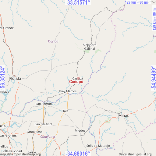
Casupá GPS coordinates[2]
34° 5' 59.784" South, 55° 38' 53.196" West
| Map corner | latitude | longitude |
|---|---|---|
| Upper-left | -33.51571°, | -56.35124° |
| Center: | -34.09994°, | -55.64811° |
| Lower-right: | -34.68016°, | -54.94499° |
| Map W x H: | 129.5×129.5 km | = 80.5×80.5mi |
| max Lat: | -30.25966° ⇑52.5% North |
| Casupá: | -34.09994° |
| min Lat: | ⇓47.5% South -34.94747° |
| min Long | Casupá | max Long |
| -58.41176° | -55.64811° | -53.38583° |
| W 69.7%⇐ | ⇒30.3% E |
Elevation
Elevation of Casupá is 125 m = 410 ft, and this is 54.4 m = 178 ft above average elevation for this country.
| Max E: |
294 m = 965 ft | 18% |
| Casupá | 125 m 410 ft | |
| Avg. | 70.6 m = 232 ft | |
Min E: |
2 m = 7 ft | 82% |
See also: Uruguay elevation on elevation.city.
Geographical zone
Casupá is located in South temperate zone (between Tropic of Capricorn and the Antarctic Circle). Distance of this Southern Tropic circle is 1185.6 km =736.7 mi to North.| Distance of | km | miles | from Casupá |
|---|---|---|---|
| Equator | 3791.6 | 2356 | to North |
| Tropic Capricorn | 1185.6 | 736.7 | to North |
| Antarctic Circle | 3609.6 | 2242.9 | to South |
| South Pole | 6215.5 | 3862.1 | to South |


Nearby cities:
15 places around Casupá: (largest is in red/bold)
• 25 de Mayo
64.4 km =40 mi,  261°
261°
• Alejandro Gallinal
28.1 km =17.5 mi,  20°
20°
• Empalme Olmos
70.1 km =43.6 mi,  198°
198°
• Florida
52.1 km =32.4 mi,  270°
270°
• Migues
43.1 km =26.8 mi,  177°
177°
• Minas
48.6 km =30.2 mi,  129°
129°
• Montes
44.5 km =27.7 mi,  169°
169°
• San Antonio
55.7 km =34.6 mi,  225°
225°
• San Bautista
47.4 km =29.5 mi,  217°
217°
• San Jacinto
53.5 km =33.2 mi, 202°
• San Ramón
35.4 km =22 mi, 233°
• Santa Rosa
56.9 km =35.4 mi, 218°
• Soca
65.2 km =40.5 mi, 184°
• Solís de Mataojo
58 km =36 mi,  163°
163°
• Tala
29.1 km =18.1 mi, 201°
Sources, notices
• [Note1] Compared only with cities in Uruguay existing in our database
• [Src1] Map data: © OpenStreetMap contributors (CC-BY-SA)
• [Src2] Other city data from geonames.org with taken over terms of usage.
• [Src3] Geographical zone / Annual Mean Temperature by Robert A. Rohde @ Wikipedia
