Villa Sara geodata
Villa Sara (Treinta y Tres) is a populated place; located in Uruguay in America/Montevideo (GMT-3) time zone. With population of 1,071 people, there are 118 cities with bigger population in this country. Compared to other cities in Uruguay, 68.9% of cities are located further ↓South; 88.5% of cities are located further ←West and 64.8% of cities have higher elevation than Villa Sara. Note1


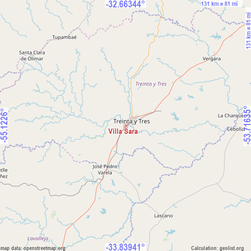
Villa Sara GPS coordinates[2]
33° 15' 12.24" South, 54° 25' 10.092" West
| Map corner | latitude | longitude |
|---|---|---|
| Upper-left | -32.66344°, | -55.1226° |
| Center: | -33.2534°, | -54.41947° |
| Lower-right: | -33.83941°, | -53.71635° |
| Map W x H: | 130.8×130.8 km | = 81.3×81.3mi |
| max Lat: | -30.25966° ⇑31.1% North |
| Villa Sara: | -33.2534° |
| min Lat: | ⇓68.9% South -34.94747° |
| min Long | Villa Sara | max Long |
| -58.41176° | -54.41947° | -53.38583° |
| W 88.5%⇐ | ⇒11.5% E |
Elevation
Elevation of Villa Sara is 37 m = 121 ft, and this is 33.6 m = 110 ft below average elevation for this country.
| Max E: |
294 m = 965 ft | 64.8% |
| Avg. | 70.6 m = 232 ft | |
| Villa Sara | 37 m = 121 ft | |
Min E: |
2 m = 7 ft | 35.2% |
See also: Uruguay elevation on elevation.city.
Geographical zone
Villa Sara is located in South temperate zone (between Tropic of Capricorn and the Antarctic Circle). Distance of this Southern Tropic circle is 1091.5 km =678.2 mi to North.| Distance of | km | miles | from Villa Sara |
|---|---|---|---|
| Equator | 3697.4 | 2297.5 | to North |
| Tropic Capricorn | 1091.5 | 678.2 | to North |
| Antarctic Circle | 3703.7 | 2301.4 | to South |
| South Pole | 6309.6 | 3920.6 | to South |


Nearby cities:
15 places around Villa Sara: (largest is in red/bold)
• Aiguá
110.3 km =68.5 mi,  196°
196°
• Cebollatí
58.1 km =36.1 mi,  91°
91°
• Chui
101.9 km =63.3 mi,  119°
119°
• Dieciocho de Julio
93.4 km =58 mi, 120°
• José Batlle y Ordóñez
69 km =42.9 mi,  249°
249°
• José Pedro Varela
24.8 km =15.4 mi,  205°
205°
• Lascano
50.6 km =31.4 mi,  157°
157°
• Mariscala
93.6 km =58.2 mi, 200°
• Melo
101 km =62.8 mi,  13°
13°
• Santa Clara de Olimar
61.2 km =38 mi,  306°
306°
• Sarandí del Yi
113.3 km =70.4 mi,  264°
264°
• Treinta y Tres
4 km =2.5 mi,  56°
56°
• Tupambaé
56.8 km =35.3 mi,  325°
325°
• Velázquez
88 km =54.7 mi,  171°
171°
• Vergara
56.5 km =35.1 mi,  52°
52°
Sources, notices
• [Note1] Compared only with cities in Uruguay existing in our database
• [Src1] Map data: © OpenStreetMap contributors (CC-BY-SA)
• [Src2] Other city data from geonames.org with taken over terms of usage.
• [Src3] Geographical zone / Annual Mean Temperature by Robert A. Rohde @ Wikipedia
