Cebollatí geodata
Cebollatí (Rocha) is a populated place; located in Uruguay in America/Montevideo (GMT-3) time zone. With population of 1,624 people, there are 98 cities with bigger population in this country. Compared to other cities in Uruguay, 68% of cities are located further ↓South; 97.5% of cities are located further ←West and 91% of cities have higher elevation than Cebollatí. Note1


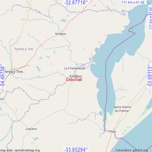
Cebollatí GPS coordinates[2]
33° 16' 1.308" South, 53° 47' 39.3" West
| Map corner | latitude | longitude |
|---|---|---|
| Upper-left | -32.67716°, | -54.49738° |
| Center: | -33.26703°, | -53.79425° |
| Lower-right: | -33.85294°, | -53.09113° |
| Map W x H: | 130.7×130.7 km | = 81.2×81.2mi |
| max Lat: | -30.25966° ⇑32% North |
| Cebollatí: | -33.26703° |
| min Lat: | ⇓68% South -34.94747° |
| min Long | Cebollatí | max Long |
| -58.41176° | -53.79425° | -53.38583° |
| W 97.5%⇐ | ⇒2.5% E |
Elevation
Elevation of Cebollatí is 12 m = 39 ft, and this is 58.6 m = 192 ft below average elevation for this country.
| Max E: |
294 m = 965 ft | 91% |
| Avg. | 70.6 m = 232 ft | |
| Cebollatí | 12 m = 39 ft | |
Min E: |
2 m = 7 ft | 9% |
See also: Uruguay elevation on elevation.city.
Geographical zone
Cebollatí is located in South temperate zone (between Tropic of Capricorn and the Antarctic Circle). Distance of this Southern Tropic circle is 1093 km =679.2 mi to North.| Distance of | km | miles | from Cebollatí |
|---|---|---|---|
| Equator | 3698.9 | 2298.4 | to North |
| Tropic Capricorn | 1093 | 679.2 | to North |
| Antarctic Circle | 3702.2 | 2300.4 | to South |
| South Pole | 6308.1 | 3919.7 | to South |


Nearby cities:
15 places around Cebollatí: (largest is in red/bold)
• Castillos
103.8 km =64.5 mi,  183°
183°
• Chui
57.1 km =35.5 mi,  147°
147°
• Dieciocho de Julio
51.3 km =31.9 mi, 154°
• José Batlle y Ordóñez
124.8 km =77.5 mi,  259°
259°
• José Pedro Varela
72 km =44.7 mi,  253°
253°
• Lascano
59.1 km =36.7 mi,  220°
220°
• Mariscala
125.2 km =77.8 mi,  226°
226°
• Melo
105.6 km =65.6 mi,  340°
340°
• Río Branco
83.6 km =51.9 mi,  27°
27°
• Santa Clara de Olimar
113.8 km =70.7 mi,  289°
289°
• Treinta y Tres
54.9 km =34.1 mi,  273°
273°
• Tupambaé
102.7 km =63.8 mi,  298°
298°
• Velázquez
96.7 km =60.1 mi,  207°
207°
• Vergara
38.3 km =23.8 mi, 339°
• Villa Sara
58.1 km =36.1 mi, 271°
Sources, notices
• [Note1] Compared only with cities in Uruguay existing in our database
• [Src1] Map data: © OpenStreetMap contributors (CC-BY-SA)
• [Src2] Other city data from geonames.org with taken over terms of usage.
• [Src3] Geographical zone / Annual Mean Temperature by Robert A. Rohde @ Wikipedia
