Qorashina geodata
Qorashina (Qashqadaryo) is a seat of a second-order administrative division; located in Uzbekistan in Asia/Samarkand (GMT+5) time zone. In our database, there are 114 cities with bigger population. Compared to other cities in Uzbekistan, 97.7% of cities are located further ↑North; 59.8% of cities are located further →East and 96% of cities have lower elevation than Qorashina. Note1


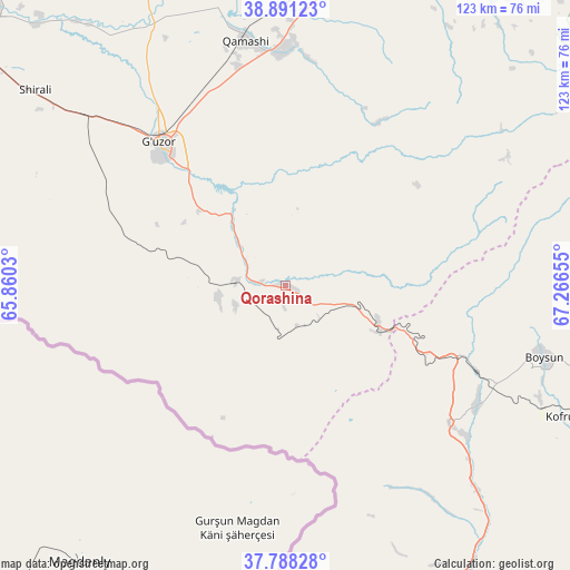
Qorashina GPS coordinates[2]
38° 20' 30.66" North, 66° 33' 48.312" East
| Map corner | latitude | longitude |
|---|---|---|
| Upper-left | 38.89123°, | 65.8603° |
| Center: | 38.34185°, | 66.56342° |
| Lower-right: | 37.78828°, | 67.26655° |
| Map W x H: | 122.6×122.6 km | = 76.2×76.2mi |
| max Lat: | 43.77877° ⇑97.7% North |
| Qorashina: | 38.34185° |
| min Lat: | ⇓2.3% South 37.22417° |
| min Long | Qorashina | max Long |
| 58.84596° | 66.56342° | 72.76177° |
| W 40.2%⇐ | ⇒59.8% E |
Elevation
Elevation of Qorashina is 939 m = 3081 ft, and this is 505.2 m = 1657 ft above average elevation for this country.
| Max E: |
1464 m = 4803 ft | 4% |
| Qorashina | 939 m 3081 ft | |
| Avg. | 433.8 m = 1423 ft | |
Min E: |
50 m = 164 ft | 96% |
See also: Uzbekistan elevation on elevation.city.
Geographical zone
Qorashina is located in North temperate zone (between Tropic of Cancer and the Arctic Circle). Distance of this Northern Tropic circle is 1657.3 km =1029.8 mi to South.| Distance of | km | miles | from Qorashina |
|---|---|---|---|
| North Pole | 5743.8 | 3569 | to North |
| Arctic Circle | 3138 | 1949.9 | to North |
| Tropic Cancer | 1657.3 | 1029.8 | to South |
| Equator | 4263.2 | 2649 | to South |


Nearby cities:
15 places around Qorashina: (largest is in red/bold)
• Beshkent
95.4 km =59.3 mi,  303°
303°
• Boysun
58.1 km =36.1 mi,  104°
104°
• Chiroqchi
76.9 km =47.8 mi,  0°
0°
• Chiroqchi Shahri
76.2 km =47.3 mi, 1°
• G‘uzor
41.4 km =25.7 mi,  318°
318°
• G‘uzor Shahri
42 km =26.1 mi, 318°
• Kitob
85.8 km =53.3 mi,  15°
15°
• Kitob Shahri
90.9 km =56.5 mi, 17°
• Nishon Tumani
86.6 km =53.8 mi, 296°
• Qamashi Shahri
53.9 km =33.5 mi,  350°
350°
• Qarshi
88.6 km =55.1 mi,  310°
310°
• Shahrisabz
83 km =51.6 mi, 16°
• Shahrisabz Shahri
82.1 km =51 mi, 15°
• Yakkabog‘ Shahri
71.4 km =44.4 mi,  8°
8°
• Yangi-Nishon Shahri
83.2 km =51.7 mi,  293°
293°
Sources, notices
• [Note1] Compared only with cities in Uzbekistan existing in our database
• [Src1] Map data: © OpenStreetMap contributors (CC-BY-SA)
• [Src2] Other city data from geonames.org with taken over terms of usage.
• [Src3] Geographical zone / Annual Mean Temperature by Robert A. Rohde @ Wikipedia
