Yaracal geodata
Yaracal (Falcón) is a seat of a second-order administrative division; located in Venezuela in America/Caracas (GMT-4) time zone. In our database, there are 108 cities with bigger population. Compared to other cities in Venezuela, 93.1% of cities are located further ↓South; 53.2% of cities are located further ←West and 76.3% of cities have higher elevation than Yaracal. Note1


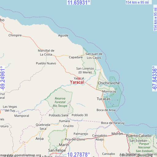
Yaracal GPS coordinates[2]
10° 58' 11.46" North, 68° 32' 47.328" West
| Map corner | latitude | longitude |
|---|---|---|
| Upper-left | 11.65931°, | -69.24961° |
| Center: | 10.96985°, | -68.54648° |
| Lower-right: | 10.27878°, | -67.84336° |
| Map W x H: | 153.5×153.5 km | = 95.4×95.4mi |
| max Lat: | 11.94788° ⇑6.9% North |
| Yaracal: | 10.96985° |
| min Lat: | ⇓93.1% South 1.92027° |
| min Long | Yaracal | max Long |
| -72.55212° | -68.54648° | -60.99778° |
| W 53.2%⇐ | ⇒46.8% E |
Elevation
Elevation of Yaracal is 62 m = 203 ft, and this is 318.6 m = 1045 ft below average elevation for this country.
| Max E: |
2986 m = 9797 ft | 76.3% |
| Avg. | 380.6 m = 1249 ft | |
| Yaracal | 62 m = 203 ft | |
Min E: |
-4 m = -13 ft | 23.7% |
See also: Venezuela elevation on elevation.city.
Geographical zone
Yaracal is located in North Torrid zone (between Equator and Tropic of Cancer). Distance of Equator is 1219.7 km =757.9 mi to South.| Distance of | km | miles | from Yaracal |
|---|---|---|---|
| North Pole | 8787.3 | 5460.2 | to North |
| Arctic Circle | 6181.4 | 3840.9 | to North |
| Tropic Cancer | 1386.2 | 861.3 | to North |
| Equator | 1219.7 | 757.9 | to South |


Nearby cities:
15 places around Yaracal: (largest is in red/bold)
• Aroa
70.2 km =43.6 mi,  212°
212°
• Chichiriviche
30.2 km =18.8 mi,  98°
98°
• Cocorote
76.8 km =47.7 mi,  199°
199°
• Farriar
55.6 km =34.5 mi,  181°
181°
• Independencia
74.3 km =46.2 mi, 197°
• Jacura
35.7 km =22.2 mi,  289°
289°
• Mirimire
28.8 km =17.9 mi,  317°
317°
• Morón
65.6 km =40.8 mi,  144°
144°
• Palmasola
41.8 km =26 mi, 179°
• Puerto Cabello
80.3 km =49.9 mi,  133°
133°
• Píritu
78.2 km =48.6 mi,  304°
304°
• San Felipe
73.2 km =45.5 mi, 197°
• San Juan de los Cayos
26.8 km =16.7 mi,  32°
32°
• Tucacas
31.3 km =19.4 mi, 129°
• Yumare
43.7 km =27.2 mi, 198°
Sources, notices
• [Note1] Compared only with cities in Venezuela existing in our database
• [Src1] Map data: © OpenStreetMap contributors (CC-BY-SA)
• [Src2] Other city data from geonames.org with taken over terms of usage.
• [Src3] Geographical zone / Annual Mean Temperature by Robert A. Rohde @ Wikipedia
