Paraíso de Chabasquén geodata
Paraíso de Chabasquén (Portuguesa) is a seat of a second-order administrative division; located in Venezuela in America/Caracas (GMT-4) time zone. In our database, there are 108 cities with bigger population. Compared to other cities in Venezuela, 52.9% of cities are located further ↑North; 63.9% of cities are located further →East and 80.2% of cities have lower elevation than Paraíso de Chabasquén. Note1
Current local time in Paraíso de Chabasquén:
03:06 PM, ThursdayDifference from your time zone: hours


Paraíso de Chabasquén GPS coordinates[2]
9° 25' 59.736" North, 69° 56' 50.208" West
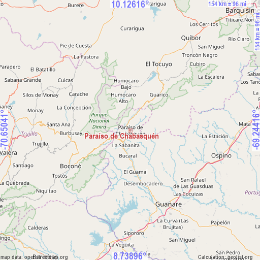
| Map corner | latitude | longitude |
|---|---|---|
| Upper-left | 10.12616°, | -70.65041° |
| Center: | 9.43326°, | -69.94728° |
| Lower-right: | 8.73896°, | -69.24416° |
| Map W x H: | 154.2×154.2 km | = 95.8×95.8mi |
| max Lat: | 11.94788° ⇑52.9% North |
| Paraíso de Chabasquén: | 9.43326° |
| min Lat: | ⇓47.1% South 1.92027° |
| min Long | Paraíso de Cha | max Long |
| -72.55212° | -69.94728° | -60.99778° |
| W 36.1%⇐ | ⇒63.9% E |
Elevation
Elevation of Paraíso de Chabasquén is 641 m = 2103 ft, and this is 260.4 m = 854 ft above average elevation for this country.
| Max E: |
2986 m = 9797 ft | 19.8% |
| Paraíso de Chabasquén | 641 m 2103 ft | |
| Avg. | 380.6 m = 1249 ft | |
Min E: |
-4 m = -13 ft | 80.2% |
See also: Venezuela elevation on elevation.city.
Geographical zone
Paraíso de Chabasquén is located in North Torrid zone (between Equator and Tropic of Cancer). Distance of Equator is 1048.9 km =651.8 mi to South.| Distance of | km | miles | from Paraíso de Chabasquén |
|---|---|---|---|
| North Pole | 8958.2 | 5566.4 | to North |
| Arctic Circle | 6352.3 | 3947.1 | to North |
| Tropic Cancer | 1557 | 967.5 | to North |
| Equator | 1048.9 | 651.8 | to South |


Nearby cities:
15 places around Paraíso de Chabasquén: (largest is in red/bold)
• Biscucuy
9 km =5.6 mi,  205°
205°
• Boconoito
65.3 km =40.6 mi,  183°
183°
• Boconó
38.8 km =24.1 mi,  239°
239°
• Campo Elías
13 km =8.1 mi,  250°
250°
• Carache
37.7 km =23.4 mi,  305°
305°
• Chejendé
49.4 km =30.7 mi,  294°
294°
• El Tocuyo
42.8 km =26.6 mi,  23°
23°
• Guanare
49 km =30.4 mi,  152°
152°
• Masparrito
61.7 km =38.3 mi,  219°
219°
• Ospino
56.2 km =34.9 mi,  105°
105°
• Pampanito
60.8 km =37.8 mi,  267°
267°
• Pampán
58 km =36 mi, 271°
• Quíbor
65.7 km =40.8 mi,  33°
33°
• Sanare
48 km =29.8 mi,  42°
42°
• Trujillo
54.2 km =33.7 mi,  262°
262°
Sources, notices
• [Note1] Compared only with cities in Venezuela existing in our database
• [Src1] Map data: © OpenStreetMap contributors (CC-BY-SA)
• [Src2] Other city data from geonames.org with taken over terms of usage.
• [Src3] Geographical zone / Annual Mean Temperature by Robert A. Rohde @ Wikipedia
