Macuto geodata
Macuto (Vargas) is a seat of a third-order administrative division; located in Venezuela in America/Caracas (GMT-4) time zone. In our database, there are 108 cities with bigger population. Compared to other cities in Venezuela, 87.8% of cities are located further ↓South; 70.7% of cities are located further ←West and 59% of cities have higher elevation than Macuto. Note1


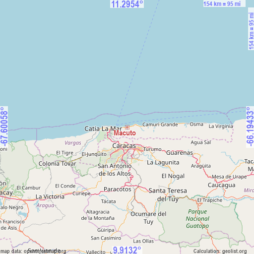
Macuto GPS coordinates[2]
10° 36' 18.288" North, 66° 53' 50.82" West
| Map corner | latitude | longitude |
|---|---|---|
| Upper-left | 11.2954°, | -67.60058° |
| Center: | 10.60508°, | -66.89745° |
| Lower-right: | 9.9132°, | -66.19433° |
| Map W x H: | 153.7×153.7 km | = 95.5×95.5mi |
| max Lat: | 11.94788° ⇑12.2% North |
| Macuto: | 10.60508° |
| min Lat: | ⇓87.8% South 1.92027° |
| min Long | Macuto | max Long |
| -72.55212° | -66.89745° | -60.99778° |
| W 70.7%⇐ | ⇒29.3% E |
Elevation
Elevation of Macuto is 142 m = 466 ft, and this is 238.6 m = 783 ft below average elevation for this country.
| Max E: |
2986 m = 9797 ft | 59% |
| Avg. | 380.6 m = 1249 ft | |
| Macuto | 142 m = 466 ft | |
Min E: |
-4 m = -13 ft | 41% |
See also: Venezuela elevation on elevation.city.
Geographical zone
Macuto is located in North Torrid zone (between Equator and Tropic of Cancer). Distance of Equator is 1179.2 km =732.7 mi to South.| Distance of | km | miles | from Macuto |
|---|---|---|---|
| North Pole | 8827.9 | 5485.4 | to North |
| Arctic Circle | 6222 | 3866.2 | to North |
| Tropic Cancer | 1426.7 | 886.5 | to North |
| Equator | 1179.2 | 732.7 | to South |


Nearby cities:
15 places around Macuto: (largest is in red/bold)
• Baruta
19.1 km =11.9 mi,  172°
172°
• Caraballeda
5 km =3.1 mi,  81°
81°
• Caracas
13.2 km =8.2 mi, 171°
• Caricuao
21.3 km =13.2 mi,  206°
206°
• Catia La Mar
14.7 km =9.1 mi,  270°
270°
• Caucagüito
21.8 km =13.5 mi,  127°
127°
• Chacao
13.1 km =8.1 mi,  158°
158°
• El Cafetal
17.2 km =10.7 mi,  154°
154°
• El Hatillo
21.6 km =13.4 mi, 158°
• La Dolorita
17.8 km =11.1 mi,  136°
136°
• La Guaira
3.9 km =2.4 mi,  264°
264°
• Los Dos Caminos
14.5 km =9 mi, 148°
• Maiquetía
6.5 km =4 mi, 259°
• Naiguatá
17.5 km =10.9 mi, 84°
• Petare
17.3 km =10.7 mi, 145°
Sources, notices
• [Note1] Compared only with cities in Venezuela existing in our database
• [Src1] Map data: © OpenStreetMap contributors (CC-BY-SA)
• [Src2] Other city data from geonames.org with taken over terms of usage.
• [Src3] Geographical zone / Annual Mean Temperature by Robert A. Rohde @ Wikipedia
