Caricuao geodata
Caricuao (Distrito Federal) is a seat of a third-order administrative division; located in Venezuela in America/Caracas (GMT-4) time zone. In our database, there are 108 cities with bigger population. Compared to other cities in Venezuela, 78.4% of cities are located further ↓South; 69.2% of cities are located further ←West and 88% of cities have lower elevation than Caricuao. Note1


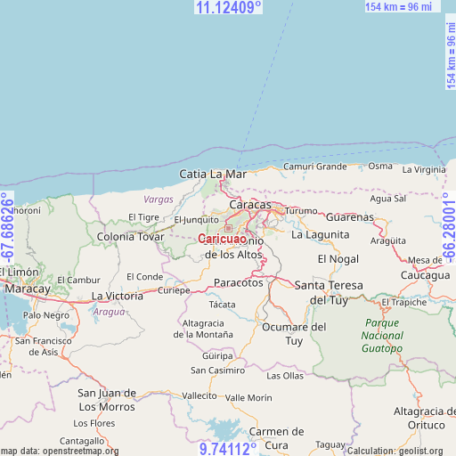
Caricuao GPS coordinates[2]
10° 26' 0.132" North, 66° 58' 59.268" West
| Map corner | latitude | longitude |
|---|---|---|
| Upper-left | 11.12409°, | -67.68626° |
| Center: | 10.43337°, | -66.98313° |
| Lower-right: | 9.74112°, | -66.28001° |
| Map W x H: | 153.8×153.8 km | = 95.6×95.6mi |
| max Lat: | 11.94788° ⇑21.6% North |
| Caricuao: | 10.43337° |
| min Lat: | ⇓78.4% South 1.92027° |
| min Long | Caricuao | max Long |
| -72.55212° | -66.98313° | -60.99778° |
| W 69.2%⇐ | ⇒30.8% E |
Elevation
Elevation of Caricuao is 976 m = 3202 ft, and this is 595.4 m = 1953 ft above average elevation for this country.
| Max E: |
2986 m = 9797 ft | 12% |
| Caricuao | 976 m 3202 ft | |
| Avg. | 380.6 m = 1249 ft | |
Min E: |
-4 m = -13 ft | 88% |
See also: Venezuela elevation on elevation.city.
Geographical zone
Caricuao is located in North Torrid zone (between Equator and Tropic of Cancer). Distance of Equator is 1160.1 km =720.9 mi to South.| Distance of | km | miles | from Caricuao |
|---|---|---|---|
| North Pole | 8847 | 5497.3 | to North |
| Arctic Circle | 6241.1 | 3878 | to North |
| Tropic Cancer | 1445.8 | 898.4 | to North |
| Equator | 1160.1 | 720.9 | to South |


Nearby cities:
15 places around Caricuao: (largest is in red/bold)
• Baruta
11.8 km =7.3 mi,  89°
89°
• Caracas
12.9 km =8 mi,  61°
61°
• Carrizal
9.3 km =5.8 mi,  182°
182°
• Catia La Mar
19.9 km =12.4 mi,  344°
344°
• Chacao
15.8 km =9.8 mi, 63°
• El Cafetal
17.2 km =10.7 mi,  78°
78°
• El Hatillo
17.2 km =10.7 mi, 93°
• El Junko
11.8 km =7.3 mi,  291°
291°
• La Guaira
19.5 km =12.1 mi,  16°
16°
• Los Dos Caminos
18.2 km =11.3 mi,  68°
68°
• Los Teques
11.9 km =7.4 mi,  213°
213°
• Macuto
21.3 km =13.2 mi,  26°
26°
• Maiquetía
18.2 km =11.3 mi,  9°
9°
• Petare
19.8 km =12.3 mi, 75°
• San Antonio de Los Altos
6.1 km =3.8 mi,  145°
145°
Sources, notices
• [Note1] Compared only with cities in Venezuela existing in our database
• [Src1] Map data: © OpenStreetMap contributors (CC-BY-SA)
• [Src2] Other city data from geonames.org with taken over terms of usage.
• [Src3] Geographical zone / Annual Mean Temperature by Robert A. Rohde @ Wikipedia
