El Hatillo geodata
El Hatillo (Miranda) is a seat of a second-order administrative division; located in Venezuela in America/Caracas (GMT-4) time zone. With population of 57,591 people, there are 67 cities with bigger population in this country. Compared to other cities in Venezuela, 78.1% of cities are located further ↓South; 73% of cities are located further ←West and 93.4% of cities have lower elevation than El Hatillo. Note1


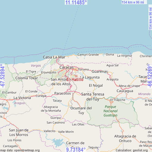
El Hatillo GPS coordinates[2]
10° 25' 26.796" North, 66° 49' 32.916" West
| Map corner | latitude | longitude |
|---|---|---|
| Upper-left | 11.11485°, | -67.52894° |
| Center: | 10.42411°, | -66.82581° |
| Lower-right: | 9.73184°, | -66.12269° |
| Map W x H: | 153.8×153.8 km | = 95.6×95.6mi |
| max Lat: | 11.94788° ⇑21.9% North |
| El Hatillo: | 10.42411° |
| min Lat: | ⇓78.1% South 1.92027° |
| min Long | El Hatillo | max Long |
| -72.55212° | -66.82581° | -60.99778° |
| W 73%⇐ | ⇒27% E |
Elevation
Elevation of El Hatillo is 1222 m = 4009 ft, and this is 841.4 m = 2760 ft above average elevation for this country.
| Max E: |
2986 m = 9797 ft | 6.6% |
| El Hatillo | 1222 m 4009 ft | |
| Avg. | 380.6 m = 1249 ft | |
Min E: |
-4 m = -13 ft | 93.4% |
See also: El Hatillo elevation on elevation.city.
Geographical zone
El Hatillo is located in North Torrid zone (between Equator and Tropic of Cancer). Distance of Equator is 1159.1 km =720.2 mi to South.| Distance of | km | miles | from El Hatillo |
|---|---|---|---|
| North Pole | 8848 | 5497.9 | to North |
| Arctic Circle | 6242.1 | 3878.7 | to North |
| Tropic Cancer | 1446.9 | 899.1 | to North |
| Equator | 1159.1 | 720.2 | to South |


Nearby cities:
15 places around El Hatillo: (largest is in red/bold)
• Baruta
5.6 km =3.5 mi,  281°
281°
• Caraballeda
21.1 km =13.1 mi,  352°
352°
• Caracas
9.2 km =5.7 mi,  320°
320°
• Caricuao
17.2 km =10.7 mi,  273°
273°
• Carrizal
19.4 km =12.1 mi,  244°
244°
• Caucaguita
7.8 km =4.8 mi,  160°
160°
• Caucagüito
11.9 km =7.4 mi,  54°
54°
• Chacao
8.5 km =5.3 mi,  339°
339°
• Charallave
20.5 km =12.7 mi,  189°
189°
• El Cafetal
4.6 km =2.9 mi, 354°
• La Dolorita
8.4 km =5.2 mi,  31°
31°
• Los Dos Caminos
7.8 km =4.8 mi,  357°
357°
• Macuto
21.6 km =13.4 mi, 338°
• Petare
6.2 km =3.9 mi,  18°
18°
• San Antonio de Los Altos
14.3 km =8.9 mi,  253°
253°
Sources, notices
• [Note1] Compared only with cities in Venezuela existing in our database
• [Src1] Map data: © OpenStreetMap contributors (CC-BY-SA)
• [Src2] Other city data from geonames.org with taken over terms of usage.
• [Src3] Geographical zone / Annual Mean Temperature by Robert A. Rohde @ Wikipedia
