Caracas geodata
Caracas (Distrito Federal) is a capital of a political entity; located in Venezuela in America/Caracas (GMT-4) time zone. With population of 3,000,000 people, there are 0 cities with bigger population in this country. Compared to other cities in Venezuela, 82.7% of cities are located further ↓South; 71.2% of cities are located further ←West and 85.5% of cities have lower elevation than Caracas. Note1


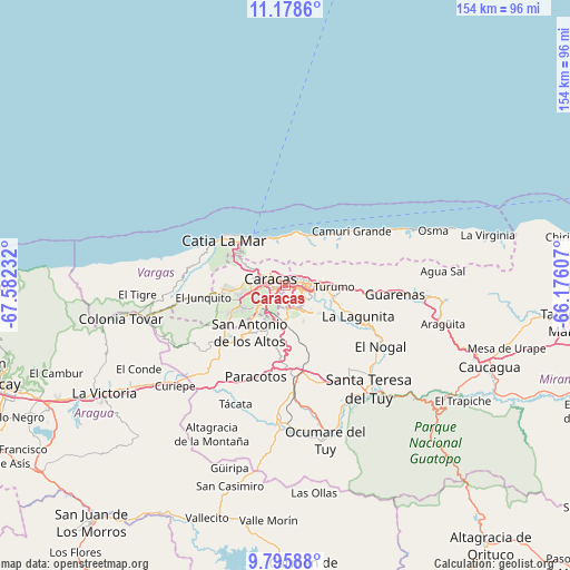
Caracas GPS coordinates[2]
10° 29' 16.836" North, 66° 52' 45.084" West
| Map corner | latitude | longitude |
|---|---|---|
| Upper-left | 11.1786°, | -67.58232° |
| Center: | 10.48801°, | -66.87919° |
| Lower-right: | 9.79588°, | -66.17607° |
| Map W x H: | 153.7×153.7 km | = 95.5×95.5mi |
| max Lat: | 11.94788° ⇑17.3% North |
| Caracas: | 10.48801° |
| min Lat: | ⇓82.7% South 1.92027° |
| min Long | Caracas | max Long |
| -72.55212° | -66.87919° | -60.99778° |
| W 71.2%⇐ | ⇒28.8% E |
Elevation
Elevation of Caracas is 887 m = 2910 ft, and this is 506.4 m = 1661 ft above average elevation for this country.
| Max E: |
2986 m = 9797 ft | 14.5% |
| Caracas | 887 m 2910 ft | |
| Avg. | 380.6 m = 1249 ft | |
Min E: |
-4 m = -13 ft | 85.5% |
See also: Caracas elevation on elevation.city.
Geographical zone
Caracas is located in North Torrid zone (between Equator and Tropic of Cancer). Distance of Equator is 1166.2 km =724.6 mi to South.| Distance of | km | miles | from Caracas |
|---|---|---|---|
| North Pole | 8840.9 | 5493.5 | to North |
| Arctic Circle | 6235 | 3874.2 | to North |
| Tropic Cancer | 1439.8 | 894.6 | to North |
| Equator | 1166.2 | 724.6 | to South |


Nearby cities:
15 places around Caracas: (largest is in red/bold)
• Baruta
6 km =3.7 mi,  176°
176°
• Caraballeda
14.1 km =8.8 mi,  12°
12°
• Caricuao
12.9 km =8 mi,  241°
241°
• Caucaguita
16.7 km =10.4 mi,  149°
149°
• Caucagüito
15.4 km =9.6 mi,  90°
90°
• Chacao
2.9 km =1.8 mi,  72°
72°
• El Cafetal
6 km =3.7 mi,  114°
114°
• El Hatillo
9.2 km =5.7 mi,  140°
140°
• La Dolorita
10.2 km =6.3 mi, 89°
• La Guaira
13.9 km =8.6 mi,  335°
335°
• Los Dos Caminos
5.6 km =3.5 mi,  83°
83°
• Macuto
13.2 km =8.2 mi,  351°
351°
• Maiquetía
14.5 km =9 mi,  324°
324°
• Petare
7.9 km =4.9 mi,  99°
99°
• San Antonio de Los Altos
13.6 km =8.5 mi,  215°
215°
Sources, notices
• [Note1] Compared only with cities in Venezuela existing in our database
• [Src1] Map data: © OpenStreetMap contributors (CC-BY-SA)
• [Src2] Other city data from geonames.org with taken over terms of usage.
• [Src3] Geographical zone / Annual Mean Temperature by Robert A. Rohde @ Wikipedia
