Baruta geodata
Baruta (Miranda) is a seat of a second-order administrative division; located in Venezuela in America/Caracas (GMT-4) time zone. With population of 244,216 people, there are 18 cities with bigger population in this country. Compared to other cities in Venezuela, 78.6% of cities are located further ↓South; 71.5% of cities are located further ←West and 91.3% of cities have lower elevation than Baruta. Note1


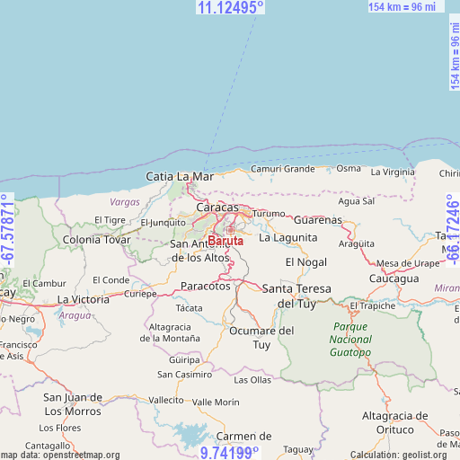
Baruta GPS coordinates[2]
10° 26' 3.264" North, 66° 52' 32.088" West
| Map corner | latitude | longitude |
|---|---|---|
| Upper-left | 11.12495°, | -67.57871° |
| Center: | 10.43424°, | -66.87558° |
| Lower-right: | 9.74199°, | -66.17246° |
| Map W x H: | 153.8×153.8 km | = 95.6×95.6mi |
| max Lat: | 11.94788° ⇑21.4% North |
| Baruta: | 10.43424° |
| min Lat: | ⇓78.6% South 1.92027° |
| min Long | Baruta | max Long |
| -72.55212° | -66.87558° | -60.99778° |
| W 71.5%⇐ | ⇒28.5% E |
Elevation
Elevation of Baruta is 1139 m = 3737 ft, and this is 758.4 m = 2488 ft above average elevation for this country.
| Max E: |
2986 m = 9797 ft | 8.7% |
| Baruta | 1139 m 3737 ft | |
| Avg. | 380.6 m = 1249 ft | |
Min E: |
-4 m = -13 ft | 91.3% |
See also: Baruta elevation on elevation.city.
Geographical zone
Baruta is located in North Torrid zone (between Equator and Tropic of Cancer). Distance of Equator is 1160.2 km =720.9 mi to South.| Distance of | km | miles | from Baruta |
|---|---|---|---|
| North Pole | 8846.9 | 5497.2 | to North |
| Arctic Circle | 6241 | 3878 | to North |
| Tropic Cancer | 1445.7 | 898.3 | to North |
| Equator | 1160.2 | 720.9 | to South |


Nearby cities:
15 places around Baruta: (largest is in red/bold)
• Caracas
6 km =3.7 mi,  356°
356°
• Caricuao
11.8 km =7.3 mi,  269°
269°
• Carrizal
15.3 km =9.5 mi,  232°
232°
• Caucaguita
11.7 km =7.3 mi,  136°
136°
• Caucagüito
16.1 km =10 mi,  68°
68°
• Chacao
7.3 km =4.5 mi,  19°
19°
• El Cafetal
6.1 km =3.8 mi,  55°
55°
• El Hatillo
5.6 km =3.5 mi,  101°
101°
• La Dolorita
11.5 km =7.1 mi, 58°
• La Guaira
19.6 km =12.2 mi,  341°
341°
• Los Dos Caminos
8.4 km =5.2 mi,  37°
37°
• Macuto
19.1 km =11.9 mi,  352°
352°
• Maiquetía
19.9 km =12.4 mi,  333°
333°
• Petare
8.8 km =5.5 mi, 57°
• San Antonio de Los Altos
9.8 km =6.1 mi,  238°
238°
Sources, notices
• [Note1] Compared only with cities in Venezuela existing in our database
• [Src1] Map data: © OpenStreetMap contributors (CC-BY-SA)
• [Src2] Other city data from geonames.org with taken over terms of usage.
• [Src3] Geographical zone / Annual Mean Temperature by Robert A. Rohde @ Wikipedia
