Petare geodata
Petare (Miranda) is a seat of a second-order administrative division; located in Venezuela in America/Caracas (GMT-4) time zone. With population of 364,684 people, there are 9 cities with bigger population in this country. Compared to other cities in Venezuela, 81.7% of cities are located further ↓South; 73.3% of cities are located further ←West and 86.8% of cities have lower elevation than Petare. Note1


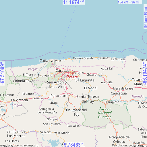
Petare GPS coordinates[2]
10° 28' 36.444" North, 66° 48' 28.296" West
| Map corner | latitude | longitude |
|---|---|---|
| Upper-left | 11.16741°, | -67.51099° |
| Center: | 10.47679°, | -66.80786° |
| Lower-right: | 9.78463°, | -66.10474° |
| Map W x H: | 153.8×153.8 km | = 95.6×95.6mi |
| max Lat: | 11.94788° ⇑18.3% North |
| Petare: | 10.47679° |
| min Lat: | ⇓81.7% South 1.92027° |
| min Long | Petare | max Long |
| -72.55212° | -66.80786° | -60.99778° |
| W 73.3%⇐ | ⇒26.7% E |
Elevation
Elevation of Petare is 914 m = 2999 ft, and this is 533.4 m = 1750 ft above average elevation for this country.
| Max E: |
2986 m = 9797 ft | 13.2% |
| Petare | 914 m 2999 ft | |
| Avg. | 380.6 m = 1249 ft | |
Min E: |
-4 m = -13 ft | 86.8% |
See also: Petare elevation on elevation.city.
Geographical zone
Petare is located in North Torrid zone (between Equator and Tropic of Cancer). Distance of Equator is 1164.9 km =723.8 mi to South.| Distance of | km | miles | from Petare |
|---|---|---|---|
| North Pole | 8842.2 | 5494.3 | to North |
| Arctic Circle | 6236.3 | 3875.1 | to North |
| Tropic Cancer | 1441 | 895.4 | to North |
| Equator | 1164.9 | 723.8 | to South |


Nearby cities:
15 places around Petare: (largest is in red/bold)
• Baruta
8.8 km =5.5 mi,  237°
237°
• Caraballeda
15.8 km =9.8 mi,  342°
342°
• Caracas
7.9 km =4.9 mi,  279°
279°
• Caricuao
19.8 km =12.3 mi,  255°
255°
• Caucaguita
13.2 km =8.2 mi,  177°
177°
• Caucagüito
7.7 km =4.8 mi,  81°
81°
• Chacao
5.4 km =3.4 mi,  292°
292°
• El Cafetal
2.7 km =1.7 mi, 241°
• El Hatillo
6.2 km =3.9 mi,  198°
198°
• La Dolorita
2.7 km =1.7 mi,  61°
61°
• La Guaira
19.5 km =12.1 mi,  315°
315°
• Los Dos Caminos
3 km =1.9 mi,  309°
309°
• Macuto
17.3 km =10.7 mi,  325°
325°
• Naiguatá
17.7 km =11 mi,  25°
25°
• San Antonio de Los Altos
18.5 km =11.5 mi, 238°
Sources, notices
• [Note1] Compared only with cities in Venezuela existing in our database
• [Src1] Map data: © OpenStreetMap contributors (CC-BY-SA)
• [Src2] Other city data from geonames.org with taken over terms of usage.
• [Src3] Geographical zone / Annual Mean Temperature by Robert A. Rohde @ Wikipedia
