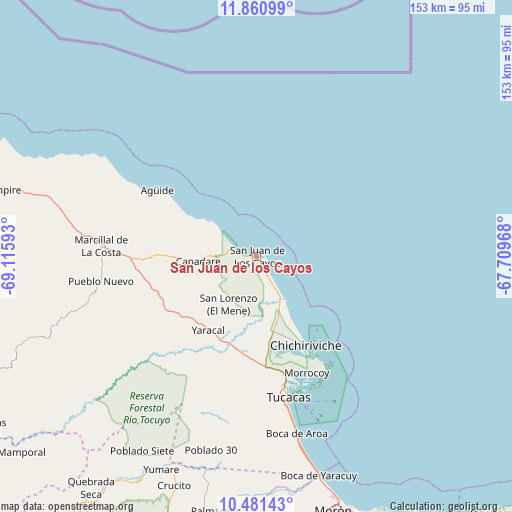
San Juan de los Cayos geodata
San Juan de los Cayos (Falcón) is a seat of a second-order administrative division; located in Venezuela in America/Caracas (GMT-4) time zone. In our database, there are 108 cities with bigger population. Compared to other cities in Venezuela, 97.2% of cities are located further ↓South; 54.5% of cities are located further ←West and 99.2% of cities have higher elevation than San Juan de los Cayos. Note1
Current local time in San Juan de los Cayos:
02:05 PM, ThursdayDifference from your time zone: hours


San Juan de los Cayos GPS coordinates[2]
11° 10' 19.308" North, 68° 24' 46.08" West
| Map corner | latitude | longitude |
|---|---|---|
| Upper-left | 11.86099°, | -69.11593° |
| Center: | 11.17203°, | -68.4128° |
| Lower-right: | 10.48143°, | -67.70968° |
| Map W x H: | 153.4×153.4 km | = 95.3×95.3mi |
| max Lat: | 11.94788° ⇑2.8% North |
| San Juan de los Cayos: | 11.17203° |
| min Lat: | ⇓97.2% South 1.92027° |
| min Long | San Juan de los | max Long |
| -72.55212° | -68.4128° | -60.99778° |
| W 54.5%⇐ | ⇒45.5% E |
Elevation
Elevation of San Juan de los Cayos is 1 m = 3 ft, and this is 379.6 m = 1245 ft below average elevation for this country.
| Max E: |
2986 m = 9797 ft | 99.2% |
| Avg. | 380.6 m = 1249 ft | |
| San Juan de los Cayos | 1 m = 3 ft | |
Min E: |
-4 m = -13 ft | 0.8% |
See also: Venezuela elevation on elevation.city.
Geographical zone
San Juan de los Cayos is located in North Torrid zone (between Equator and Tropic of Cancer). Distance of Equator is 1242.2 km =771.9 mi to South.| Distance of | km | miles | from San Juan de los Cayos |
|---|---|---|---|
| North Pole | 8764.8 | 5446.2 | to North |
| Arctic Circle | 6159 | 3827 | to North |
| Tropic Cancer | 1363.7 | 847.4 | to North |
| Equator | 1242.2 | 771.9 | to South |


Nearby cities:
15 places around San Juan de los Cayos: (largest is in red/bold)
• Aroa
97 km =60.3 mi,  212°
212°
• Chichiriviche
31.1 km =19.3 mi,  150°
150°
• Farriar
79.7 km =49.5 mi,  191°
191°
• Independencia
100.4 km =62.4 mi,  201°
201°
• Jacura
49.5 km =30.8 mi,  257°
257°
• Mirimire
34.2 km =21.3 mi,  267°
267°
• Morón
79.6 km =49.5 mi,  163°
163°
• Palmasola
65.9 km =40.9 mi, 192°
• Puerto Cabello
89.2 km =55.4 mi, 150°
• Píritu
82 km =51 mi,  285°
285°
• San Felipe
99.3 km =61.7 mi, 201°
• Tocópero
99.2 km =61.6 mi, 291°
• Tucacas
43.5 km =27 mi,  167°
167°
• Yaracal
26.8 km =16.7 mi, 212°
• Yumare
70 km =43.5 mi, 203°
Sources, notices
• [Note1] Compared only with cities in Venezuela existing in our database
• [Src1] Map data: © OpenStreetMap contributors (CC-BY-SA)
• [Src2] Other city data from geonames.org with taken over terms of usage.
• [Src3] Geographical zone / Annual Mean Temperature by Robert A. Rohde @ Wikipedia
