San Antonio de Los Altos geodata
San Antonio de Los Altos (Miranda) is a seat of a second-order administrative division; located in Venezuela in America/Caracas (GMT-4) time zone. With population of 63,873 people, there are 60 cities with bigger population in this country. Compared to other cities in Venezuela, 77.4% of cities are located further ↓South; 70% of cities are located further ←West and 95.2% of cities have lower elevation than San Antonio de Los Altos. Note1
Current local time in San Antonio de Los Altos:
10:54 AM, SundayDifference from your time zone: hours


San Antonio de Los Altos GPS coordinates[2]
10° 23' 18.708" North, 66° 57' 6.444" West
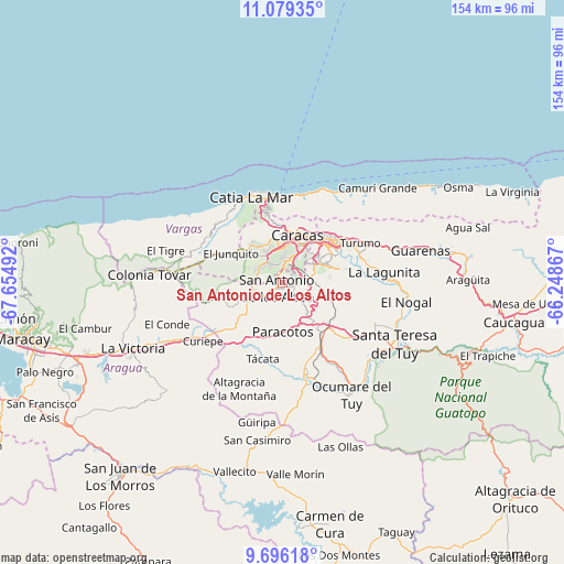
| Map corner | latitude | longitude |
|---|---|---|
| Upper-left | 11.07935°, | -67.65492° |
| Center: | 10.38853°, | -66.95179° |
| Lower-right: | 9.69618°, | -66.24867° |
| Map W x H: | 153.8×153.8 km | = 95.6×95.6mi |
| max Lat: | 11.94788° ⇑22.6% North |
| San Antonio de Los Altos: | 10.38853° |
| min Lat: | ⇓77.4% South 1.92027° |
| min Long | San Antonio de | max Long |
| -72.55212° | -66.95179° | -60.99778° |
| W 70%⇐ | ⇒30% E |
Elevation
Elevation of San Antonio de Los Altos is 1396 m = 4580 ft, and this is 1015.4 m = 3331 ft above average elevation for this country.
| Max E: |
2986 m = 9797 ft | 4.8% |
| San Antonio de Los Altos | 1396 m 4580 ft | |
| Avg. | 380.6 m = 1249 ft | |
Min E: |
-4 m = -13 ft | 95.2% |
See also: San Antonio de Los Altos elevation on elevation.city.
Geographical zone
San Antonio de Los Altos is located in North Torrid zone (between Equator and Tropic of Cancer). Distance of Equator is 1155.1 km =717.7 mi to South.| Distance of | km | miles | from San Antonio de Los Altos |
|---|---|---|---|
| North Pole | 8852 | 5500.4 | to North |
| Arctic Circle | 6246.1 | 3881.1 | to North |
| Tropic Cancer | 1450.8 | 901.5 | to North |
| Equator | 1155.1 | 717.7 | to South |


Nearby cities:
15 places around San Antonio de Los Altos: (largest is in red/bold)
• Baruta
9.8 km =6.1 mi,  58°
58°
• Caracas
13.6 km =8.5 mi,  35°
35°
• Caricuao
6.1 km =3.8 mi,  325°
325°
• Carrizal
5.7 km =3.5 mi,  221°
221°
• Caucaguita
16.7 km =10.4 mi,  101°
101°
• Chacao
16 km =9.9 mi, 41°
• Charallave
19.3 km =12 mi,  147°
147°
• El Cafetal
15.9 km =9.9 mi, 57°
• El Hatillo
14.3 km =8.9 mi,  73°
73°
• El Junko
17.2 km =10.7 mi,  302°
302°
• La Dolorita
21.2 km =13.2 mi, 58°
• Los Dos Caminos
17.8 km =11.1 mi,  48°
48°
• Los Teques
11.1 km =6.9 mi,  243°
243°
• Maiquetía
22.9 km =14.2 mi,  358°
358°
• Petare
18.5 km =11.5 mi, 58°
Sources, notices
• [Note1] Compared only with cities in Venezuela existing in our database
• [Src1] Map data: © OpenStreetMap contributors (CC-BY-SA)
• [Src2] Other city data from geonames.org with taken over terms of usage.
• [Src3] Geographical zone / Annual Mean Temperature by Robert A. Rohde @ Wikipedia
