El Baúl geodata
El Baúl (Cojedes) is a seat of a second-order administrative division; located in Venezuela in America/Caracas (GMT-4) time zone. In our database, there are 108 cities with bigger population. Compared to other cities in Venezuela, 64.6% of cities are located further ↑North; 56% of cities are located further ←West and 74.8% of cities have higher elevation than El Baúl. Note1


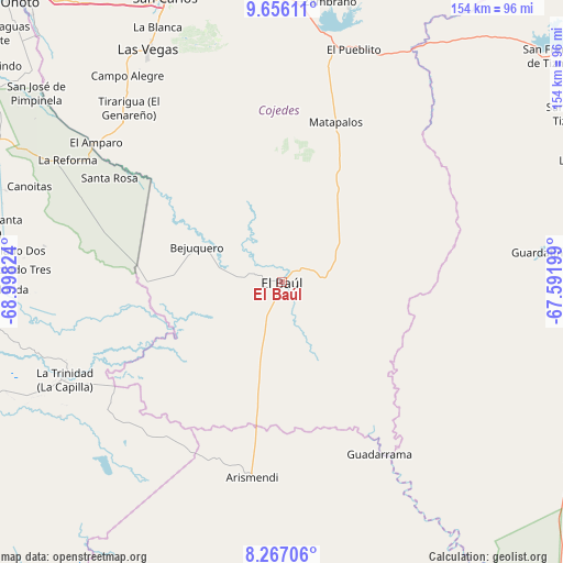
El Baúl GPS coordinates[2]
8° 57' 44.1" North, 68° 17' 42.396" West
| Map corner | latitude | longitude |
|---|---|---|
| Upper-left | 9.65611°, | -68.99824° |
| Center: | 8.96225°, | -68.29511° |
| Lower-right: | 8.26706°, | -67.59199° |
| Map W x H: | 154.4×154.5 km | = 95.9×96mi |
| max Lat: | 11.94788° ⇑64.6% North |
| El Baúl: | 8.96225° |
| min Lat: | ⇓35.4% South 1.92027° |
| min Long | El Baúl | max Long |
| -72.55212° | -68.29511° | -60.99778° |
| W 56%⇐ | ⇒44% E |
Elevation
Elevation of El Baúl is 68 m = 223 ft, and this is 312.6 m = 1026 ft below average elevation for this country.
| Max E: |
2986 m = 9797 ft | 74.8% |
| Avg. | 380.6 m = 1249 ft | |
| El Baúl | 68 m = 223 ft | |
Min E: |
-4 m = -13 ft | 25.2% |
See also: Venezuela elevation on elevation.city.
Geographical zone
El Baúl is located in North Torrid zone (between Equator and Tropic of Cancer). Distance of Equator is 996.5 km =619.2 mi to South.| Distance of | km | miles | from El Baúl |
|---|---|---|---|
| North Pole | 9010.6 | 5598.9 | to North |
| Arctic Circle | 6404.7 | 3979.7 | to North |
| Tropic Cancer | 1609.4 | 1000 | to North |
| Equator | 996.5 | 619.2 | to South |


Nearby cities:
15 places around El Baúl: (largest is in red/bold)
• Arismendi
54.3 km =33.7 mi,  188°
188°
• Calabozo
95.2 km =59.2 mi,  92°
92°
• Cojedes
100.3 km =62.3 mi,  317°
317°
• El Pao
77.4 km =48.1 mi,  13°
13°
• El Playón
83.8 km =52.1 mi,  280°
280°
• Guadarrama
54.6 km =33.9 mi,  150°
150°
• Guanarito
104.6 km =65 mi,  253°
253°
• La Unión
101.3 km =62.9 mi, 145°
• Las Vegas
73.8 km =45.9 mi,  330°
330°
• Libertad
61.8 km =38.4 mi, 315°
• Macapo
97.2 km =60.4 mi,  350°
350°
• San Carlos
83.9 km =52.1 mi,  337°
337°
• Tinaco
83.3 km =51.8 mi, 349°
• Tinaquillo
106.3 km =66.1 mi,  359°
359°
• Villa Bruzual
99.4 km =61.8 mi,  294°
294°
Sources, notices
• [Note1] Compared only with cities in Venezuela existing in our database
• [Src1] Map data: © OpenStreetMap contributors (CC-BY-SA)
• [Src2] Other city data from geonames.org with taken over terms of usage.
• [Src3] Geographical zone / Annual Mean Temperature by Robert A. Rohde @ Wikipedia
